

- Usage in publication:
-
- Hazel sandstone
- Modifications:
-
- First used
- Dominant lithology:
-
- Sandstone
- AAPG geologic province:
-
- Southwestern Basin-and-Range region
Summary:
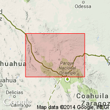
First used as a name for a red sandstone in the Diabolo Mountains north of Allamore Station on the Texas and Pacific Railway, Hudspeth Co, TX in the Southwestern Basin-and-Range region. The sandstone is very massive, is even grained, and has some white particles in it. Probably named for the Hazel mine, though author does not give the derivation of name Hazel, the intent to name, or the type locality. Is 500 ft thick. Age not stated. Forms basal part of section. Overlain by limestone of Silurian age at some localities, and by limestone of Carboniferous age at others.
Source: GNU records (USGS DDS-6; Denver GNULEX).
- Usage in publication:
-
- Hazel sandstone*
- Modifications:
-
- Reinstated
- Dominant lithology:
-
- Sandstone
- Conglomerate
- AAPG geologic province:
-
- Southwestern Basin-and-Range region
Summary:
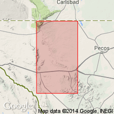
Pg. 144 (fig. 1), 145 (table), 148, 149-150. Hazel sandstone. Restored to formal nomenclature. Millican formation of Richardson divided into two formations and term Millican abandoned. Dumble's term Hazel sandstone is applied to upper of the two formations and Allamoore limestone is proposed for lower formation; these are separated by a marked unconformity. Consists of conglomerate which passes upward into red sandstone. Conglomerate consists largely of limestone fragments ranging from pebbles to large, angular blocks 6 feet or more across. Red sandstone described as very fine-grained, well-consolidated, marked by thin, dark, cross-bedded laminae. Formation heavily-jointed and bedding tends to be obscured. Thicknesses of conglomerate and sandstone not measured but estimated to be thousands of feet. At many places where conglomerate stands vertically it forms belts of outcrop nearly a mile wide (may be some duplication by folding). North of Hazel mine on Sierra Diablo escarpment exposed thickness of red sandstone is at least 2,000 feet, neither base nor top exposed. Succeeded by Van Horn sandstone. Age is Precambrian. Report includes stratigraphic chart, regional sketch map.
Source: US geologic names lexicon (USGS Bull. 1200, p. 1714); supplemental information from GNU records (USGS DDS-6; Denver GNULEX).
- Usage in publication:
-
- Hazel Formation
- Modifications:
-
- Overview
- AAPG geologic province:
-
- Southwestern Basin-and-Range region
Summary:
Was deposited in late Precambrian time in an arid-region alluvial-fan system that was shed northward from a granitic, and interbedded diabasic volcanic and carbonate rocks. Has three principal facies: 1) proximal, chiefly limestone clast conglomerate of poorly sorted boulder- and cobble-size and thin horizontally-bedded granule-bearing arkosic sandstone; 2) mid-fan alternating limestone clast conglomerate and arkosic sandstone; 3) distal, dominantly very fine grained arkosic sandstone. Facies 1 grades north into facies 2. Facies map of area--Hudspeth and Culbertson Cos, TX, Southwestern Basin-and-Range region. Is younger than Carrizo Mountain Group. Partly coeval with Allamoore Formation. Unconformably underlies Van Horn Sandstone. Was intensely folded with Allamoore subsequently. Is more than 1,700 m thick. The upper more distal part is mainly red sandstone; the remainder is conglomerate. The thick, massive conglomerate layers grade north into sandstone. Conglomerates are separated by increasingly thicker beds of red sandstone. Thinly laminated algal stromatolites that crop out in an arcuate belt are interbedded with sandstone and conglomerate in the mid- and distal-fan. These carbonates are green, delicately crenulated and laminated. Silt-size grains of quartz, feldspar, volcanic rock trapped between algal laminations. Stratigraphic diagrams.
Source: GNU records (USGS DDS-6; Denver GNULEX).
- Usage in publication:
-
- Hazel Formation*
- Modifications:
-
- Paleomagnetics
- AAPG geologic province:
-
- Southwestern Basin-and-Range region
Summary:
Comparison made of paleomagnetic poles and polar paths of Middle Proterozoic rocks of Hazel Formation of Van Horn area, TX (Southwestern Basin-and-Range region) with Middle Proterozoic rocks elsewhere in North America. Changes in direction of apparent polar wander are interpreted to reflect plate interactions and collisions responsible for episodes of deformation on the craton. Folding phases in Van Horn and Adirondack Mountain regions are relatable to 5 direction changes of polar wander between about 1,200 and about 1,000 Ma. Hazel accumulated during an episode of south-to-north thrust faulting that has been identified as belonging to Grenville Orogeny. Hazel is a 1,500 ft thick, moderately to little deformed, purple-red, fine- to coarse-grained sandstone above Allamoore Formation and beneath Carrizo Mountain Group; is similar to Dox Sandstone, Unkar Group, Grand Canyon Supergroup of AZ (Southern Rocky Mountain region) in lithology and in lack of metamorphism. The lower, lower middle, upper parts of Hazel have normal polarity directions. Three poles from Hazel describe a short, north-south trending trace that appears to have rotated about 30 deg clockwise with respect to apex and upper part of descending leg of Unkar loop. A 30 deg counterclockwise vertical-axis rotation brings Hazel into general coincidence with upper part, middle member of Dox, and with middle and early late Keweenawan poles from Lake Superior region.
Source: GNU records (USGS DDS-6; Denver GNULEX).
For more information, please contact Nancy Stamm, Geologic Names Committee Secretary.
Asterisk (*) indicates published by U.S. Geological Survey authors.
"No current usage" (†) implies that a name has been abandoned or has fallen into disuse. Former usage and, if known, replacement name given in parentheses ( ).
Slash (/) indicates name conflicts with nomenclatural guidelines (CSN, 1933; ACSN, 1961, 1970; NACSN, 1983, 2005, 2021). May be explained within brackets ([ ]).