The National Geologic Map Database is migrating to a new infrastructure. We apologize for any service disruptions during this process.
|
|---|


- Usage in publication:
-
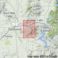
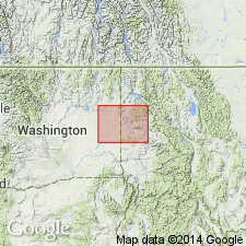
- Hauser Lake Gneiss*
- Modifications:
-
- Named
- Dominant lithology:
-
- Gneiss
- Schist
- AAPG geologic province:
-
- Northern Rocky Mountain region
Summary:
Named for exposures (its type locality) along east side of Hauser Lake, Kootenai Co, ID in the Northern Rocky Mountain region. Extends south occurring in the north part of present quad. Mapped westward into Spokane Co, WA, also in the Northern Rocky Mountain basin, just north and east of town of Spokane. Base not exposed. Gradationally underlies, over an interval of 100 to 200 ft, the newly named Newman Lake Gneiss. Composed of gray, tan, brown, mostly medium-grained layered schist and gneiss, principally quartz-feldspar-mica gneiss. Sillimanite common. Abundant dikes. Has pods and small bodies of hornblende amphibolite that contain garnet and plagioclase. Moderately granitized. Precambrian age.
Source: GNU records (USGS DDS-6; Denver GNULEX).
- Usage in publication:
-
- Hauser Lake Gneiss
- Modifications:
-
- Not used
Summary:
Not used in map area [which includes type locality]. Rocks mapped by Weis (1968) as Hauser Lake Gneiss are mapped in this report with the Prichard Formation undivided. [No explanation given for non-use of name Hauser Lake nor of its status as a formal unit.]
Source: GNU records (USGS DDS-6; Denver GNULEX).
For more information, please contact Nancy Stamm, Geologic Names Committee Secretary.
Asterisk (*) indicates published by U.S. Geological Survey authors.
"No current usage" (†) implies that a name has been abandoned or has fallen into disuse. Former usage and, if known, replacement name given in parentheses ( ).
Slash (/) indicates name conflicts with nomenclatural guidelines (CSN, 1933; ACSN, 1961, 1970; NACSN, 1983, 2005, 2021). May be explained within brackets ([ ]).