

- Usage in publication:
-
- Hastings Frobisher beds
- Modifications:
-
- Not used
- AAPG geologic province:
-
- Williston basin
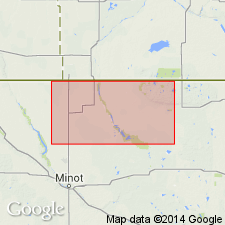
Summary:
Name not used; equivalent beds included in lower part of the M.C. 5 and M.C. 4 beds [mechanical-log interval] of the Madison group in the Bottineau area, including parts of Renville, Bottineau, and McHenry Cos, ND, Williston basin.
Source: GNU records (USGS DDS-6; Denver GNULEX).
- Usage in publication:
-
- Hastings Frobisher beds
- Modifications:
-
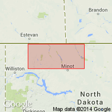
- Areal extent
- AAPG geologic province:
-
- Williston basin
Summary:
Name introduced into northwestern ND, in subsurface of the Williston basin, for an informal subdivision of the Madison group. Contacts based on radioactivity- and electric-log markers in the sense of Fuller [J.G.C.M., 1956, Mississippian rocks and oil fields in southeastern Saskatchewan: Saskatchewan Department Mineral Resources Report 19, 72 p.]. Shows correlations in cross sections extending from Divide Co eastward to Bottineau Co, and from Williams Co eastward to Bottineau Co, ND. Overlain by the Midale beds; underlain by the MC-3 unit. Mississippian in age.
Source: GNU records (USGS DDS-6; Denver GNULEX).
For more information, please contact Nancy Stamm, Geologic Names Committee Secretary.
Asterisk (*) indicates published by U.S. Geological Survey authors.
"No current usage" (†) implies that a name has been abandoned or has fallen into disuse. Former usage and, if known, replacement name given in parentheses ( ).
Slash (/) indicates name conflicts with nomenclatural guidelines (CSN, 1933; ACSN, 1961, 1970; NACSN, 1983, 2005, 2021). May be explained within brackets ([ ]).