The National Geologic Map Database is migrating to a new infrastructure. We apologize for any service disruptions during this process.
|
|---|


- Usage in publication:
-
- Hasmark formation*
- Modifications:
-
- Named
- Dominant lithology:
-
- Limestone
- Shale
- AAPG geologic province:
-
- Montana folded belt
Summary:
Named for an abandoned settlement about 1.5 miles southeast of Philipsburg, Granite Co, MT in Montana folded belt province. No type locality designated. Outcrops occur on north side of Anaconda Range, south end of Flint Creek Range, in Princeton area, and in drainage basin of Lost Creek. Lower part consists of moderately fine-grained, pale blue-gray, often gray, mottled magnesian limestone. Commonly contains oolitic structures and white twig-like bodies. Thickness is 550 ft. Middle part is brown or green calcareous shale containing few imperfect Obulus?. Thickness is 10-150 ft. Upper part is grayish to cream-white magnesian limestone. Thickness is 350 ft. Conformably overlies Cambrian Silver Hill formation (new) and conformably underlies Cambrian Red Lion formation (new). Geologic map. Measured sections. Columnar sections. Tentatively correlates with Pilgrim limestone to east. Cambrian age based on stratigraphic position.
Source: GNU records (USGS DDS-6; Denver GNULEX).
- Usage in publication:
-
- Hasmark formation
- Modifications:
-
- Areal extent
- Age modified
- AAPG geologic province:
-
- Montana folded belt
Summary:
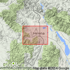
Extends Hasmark formation from Philipsburg area, Granite County, Montana, into Mount Helena area (Grizzly and Oro Fino Gulches section of Deiss, 1936), Lewis and Clark County, Montana, Montana folded belt province. At Mount Helena area, Hasmark averages 500 feet. Is very similar lithologically and stratigraphically identical to the Maurice formation of southern Montana. Overlies Silver Hill formation; underlies Red Lion formation. Age is Late Cambrian (Dresbachian).
Source: Modified from GNU records (USGS DDS-6; Denver GNULEX).
- Usage in publication:
-
- Hasmark formation
- Modifications:
-
- Areal extent
- Overview
- AAPG geologic province:
-
- Montana folded belt
Summary:
Extends name from Philipsburg quad, north of study area, to extreme southwest MT south of Boulder batholith and west of Yellowstone National Park within parts of Beaverhead, Madison and Gallatin Cos, MT, Montana folded belt province. Where no pre-Hasmark erosion occurs, unit is in transitional contact with underlying Park shale. Where pre-Hasmark erosion has occurred, unit is in disconformable contact with Park or more commonly with Meagher limestone. Northwest of Dillon, MT, unconformably overlies Flathead sandstone. Conformably underlies Red Lion formation. Thickness ranges from 200-300 ft. Correlates with parts of Nounan and St. Charles limestones in southeast ID, lower part of Pilgrim formation in central MT, Devils Glen dolomite in northwest MT and lower part of Deadwood formation in Black Hills, SD. Isopach map of Cambrian. Correlation chart. Cross section. Measured section. Late Cambrian age.
Source: GNU records (USGS DDS-6; Denver GNULEX).

- Usage in publication:
-
- Hasmark(?) formation
- Modifications:
-
- Areal extent
- AAPG geologic province:
-
- Montana folded belt
Summary:
Hasmark(?) formation. Tentatively extended from Philipsburg area, Granite County, Montana, southward into Armstead, Beaverhead County, Montana. Dolomite unit previously called Tilden formation by Shenon (1931, Montana Bur. Mines and Geol. Bull., no. 6) and Pilgrim formation by other workers. Overlies Wolsey shale and underlies Jefferson formation. Age is Middle and Late Cambrian. Report includes correlation chart, cross section.
Source: Modified from GNU records (USGS DDS-6; Denver GNULEX).
- Usage in publication:
-
- Hasmark Formation
- Modifications:
-
- Areal extent
- AAPG geologic province:
-
- Montana folded belt
Summary:
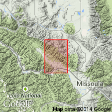
Extends unit into northwest part of Garnet Range in west-central MT, Montana folded belt province. Occurs over much of mapped area which is primarily in northern Granite Co and adjoining parts of Missoula and Powell Cos. Thickness ranges from about 1200 ft in eastern part of mapped area to about 1800 ft in western part; thickens westward with corresponding thinning of underlying Silver Hill Formation. Unconformably underlies Red Lion Formation. Geologic map. Cross sections. Stratigraphic chart. Measured section. Middle Cambrian (Albertan) age.
Source: GNU records (USGS DDS-6; Denver GNULEX).
- Usage in publication:
-
- Hasmark Dolomite*
- Modifications:
-
- Areal extent
- AAPG geologic province:
-
- Montana folded belt
Summary:
Maps in Boulder batholith area in Lewis and Clark and Jefferson Cos near Helena, MT in Montana folded belt province. Divides unit into lower part consisting of dark-gray, drab-weathering, thick-bedded dolomite and an upper part of light-gray-weathering dolomite. Overlies Middle Cambrian? Park Argillite (redefined); underlies Upper Cambrian Red Lion Formation. Equivalent to Pilgrim Dolomite in Elkhorn Mountains, and Pilgrim Limestone in Spokane Hills and Big Belt Mountains. Late Cambrian age. Geologic map.
Source: GNU records (USGS DDS-6; Denver GNULEX).
- Usage in publication:
-
- Hasmark Dolomite*
- Modifications:
-
- Areal extent
- AAPG geologic province:
-
- Montana folded belt
Summary:
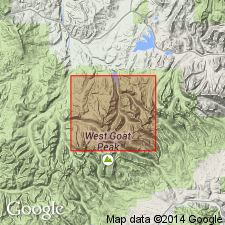
Outcrops in southern part of quad, north of Alberton in Ellis Mountain area, as well as in Ninemile Creek and Clark Fork areas in Missoula and Mineral Cos, MT in Montana folded belt province. Thickness is about 1,550 ft. Conformably overlies Middle Cambrian Silver Hill Formation; conformably underlies Upper Cambrian Red Lion Formation. Cross section. Geologic map. Middle and Late Cambrian age.
Source: GNU records (USGS DDS-6; Denver GNULEX).
- Usage in publication:
-
- Hasmark Dolomite
- Modifications:
-
- Areal extent
- AAPG geologic province:
-
- Montana folded belt
Summary:
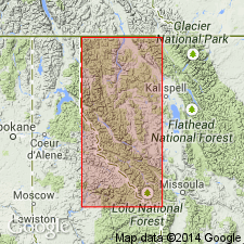
Authors propose extending Middle and Upper Cambrian units of Wells (1974) in Alberton area, Mineral Co, MT northwest to Libby area, Lincoln Co, MT, a distance of 76 mi. Within study area, located in Montana folded belt province, Hasmark overlies Silver Hill Formation and underlies Red Lion Formation. Total thickness of Cambrian units is 3248 ft in Libby area and 2380 ft in Alberton area; difference in thickness due to erosion at top of Red Lion in Alberton area. Hasmark replaces Aadland's (1979, unpublished thesis) Fishtrap Dolomite facies numbers two and three in Libby area. Hasmark was deposited as part of a carbonate shelf accumulation that began with deposition of lower limestone member of Silver Hill. Middle Cambrian age.
Source: GNU records (USGS DDS-6; Denver GNULEX).
- Usage in publication:
-
- Hasmark Formation*
- Modifications:
-
- Overview
- AAPG geologic province:
-
- Montana folded belt
Summary:
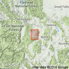
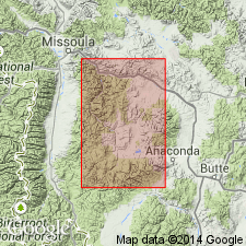
Mapped in north-central Anaconda Range, Deerlodge and Granite Cos, MT, Montana folded belt province. Hasmark mapped as defined by Emmons and Calkins (1913) and considered to be Late Cambrian age. Conformably overlies Silver Hill Formation; conformably underlies Red Lion Formation.
Source: GNU records (USGS DDS-6; Denver GNULEX).
For more information, please contact Nancy Stamm, Geologic Names Committee Secretary.
Asterisk (*) indicates published by U.S. Geological Survey authors.
"No current usage" (†) implies that a name has been abandoned or has fallen into disuse. Former usage and, if known, replacement name given in parentheses ( ).
Slash (/) indicates name conflicts with nomenclatural guidelines (CSN, 1933; ACSN, 1961, 1970; NACSN, 1983, 2005, 2021). May be explained within brackets ([ ]).