The National Geologic Map Database is migrating to a new infrastructure. We apologize for any service disruptions during this process.
|
|---|


- Usage in publication:
-
- Haskew member
- Modifications:
-
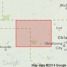
- Overview
- AAPG geologic province:
-
- Anadarko basin
Summary:
Pg. 434-437. Haskew member of Blaine formation, not previously recognized, should be accepted.
Source: US geologic names lexicon (USGS Bull. 896, p. 922).
- Usage in publication:
-
- Haskew gypsum member
- Modifications:
-
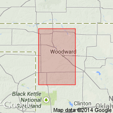
- Original reference
- AAPG geologic province:
-
- Anadarko basin
Summary:
Pg. 405-432. Haskew gypsum member of Blaine formation. Haskew proposed for top gypsum member of Blaine formation. Differs from underlying Lovedale, Shimer, and Medicine Lodge gypsum members in several particulars. Does not ordinarily have a dolomite bed at base, although a very impure sandy dolomite has been observed in a few places. Maximum thickness of Haskew member in Harper and Woodward Counties, northwestern Oklahoma, 4 feet. Separated from underlying Lovedale gypsum by 4 feet of red shale. Clusters of interlocking crystals on surface of this bed are commonly much smaller than those of underlying Lovedale, Shimer, and Medicine Lodge gypsum members, and bed is redder than the other 3. Age is Permian.
Named from exposures near old store known as Haskew Store, in northeast corner sec. 2, T. 25 N., R. 19 W., Woodward Co., northwestern OK.
Source: US geologic names lexicon (USGS Bull. 896, p. 922).
- Usage in publication:
-
- Haskew gypsum member*
- Modifications:
-
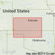
- Areal extent
- AAPG geologic province:
-
- Anadarko basin
- Sedgwick basin
Summary:
Pg. 1798. Haskew gypsum member of Blaine formation. Geographically extended into southern Kansas where it is about 1 foot thick and is exposed about 5 feet above Shimer gypsum member, red shales separating the beds. Age is Early Permian (Leonard).
Source: US geologic names lexicon (USGS Bull. 1200, p. 1697).
- Usage in publication:
-
- Haskew gypsum member
- Modifications:
-
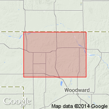
- Areal extent
- AAPG geologic province:
-
- Anadarko basin
Summary:
Pg. 31-33. Haskew gypsum member of Blaine formation. Uppermost member of Blaine. In Harper County, northwestern Oklahoma, consists of 4 feet of gypsum underlain by 4 feet of brownish-red shale. Overlies Shimer member. Age is Early Permian (Leonard).
Source: US geologic names lexicon (USGS Bull. 1200, p. 1697).
For more information, please contact Nancy Stamm, Geologic Names Committee Secretary.
Asterisk (*) indicates published by U.S. Geological Survey authors.
"No current usage" (†) implies that a name has been abandoned or has fallen into disuse. Former usage and, if known, replacement name given in parentheses ( ).
Slash (/) indicates name conflicts with nomenclatural guidelines (CSN, 1933; ACSN, 1961, 1970; NACSN, 1983, 2005, 2021). May be explained within brackets ([ ]).