

- Usage in publication:
-
- Hasen Creek Formation*
- Modifications:
-
- Named
- Biostratigraphic dating
- Dominant lithology:
-
- Chert
- Shale
- Sandstone
- Limestone
- AAPG geologic province:
-
- Alaska Southern region
Summary:
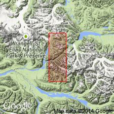
Named as upper formation (of 2) of Skolai Group (new) for Hasen Creek southeastward tributary of Chitistone River in southeastern part of McCarthy C-4 quad. Name Hasen Creek used by MacKevett and Smith (1968) with reference to this report. Type area designated as valley walls of Hasen Creek, secs.11-12 T4S R17E Copper River Meridian [McCarthy quad] southern AK. Within its upper strata unit contains Golden Horn Limestone Lentil in northern part of McCarthy C-4 quad. Hasen Creek is well exposed on slopes southwest of Golden Horn toward Skolai Creek and along Hasen Creek. Consists of heterogeneous mixture of thin-bedded chert, black shale, sandstone, carbonaceous bioclastic limestone, and minor conglomerate. Is nearly 900 ft thick excluding Golden Horn Lentil which is nearly 800 ft thick. Gradationally overlies Station Creek Formation (new) of Skolai Group; disconformably underlies Nikolai Greenstone, Wrangell Lava or Frederika Formation. Age is Early Permian on basis of paleontological evidence. Fossil list and localities included in report.
Source: GNU records (USGS DDS-6; Menlo GNULEX).
- Usage in publication:
-
- Hasen Creek Formation*
- Modifications:
-
- Age modified
- Biostratigraphic dating
- AAPG geologic province:
-
- Alaska Southern region
Summary:
Age is Artinskian (Early Permian) based on coralline fauna. List and localities of corals included in report.
Source: GNU records (USGS DDS-6; Menlo GNULEX).
- Usage in publication:
-
- Hasen Creek Formation*
- Modifications:
-
- Areal extent
- AAPG geologic province:
-
- Alaska Southern region
Summary:
Unit geographically extended into westernmost area of McCarthy quad at expense of [type locality] of Strelna Formation [which is thereby abandoned]. Age shown as Early Permian.
Source: GNU records (USGS DDS-6; Menlo GNULEX).
For more information, please contact Nancy Stamm, Geologic Names Committee Secretary.
Asterisk (*) indicates published by U.S. Geological Survey authors.
"No current usage" (†) implies that a name has been abandoned or has fallen into disuse. Former usage and, if known, replacement name given in parentheses ( ).
Slash (/) indicates name conflicts with nomenclatural guidelines (CSN, 1933; ACSN, 1961, 1970; NACSN, 1983, 2005, 2021). May be explained within brackets ([ ]).