The National Geologic Map Database is migrating to a new infrastructure. We apologize for any service disruptions during this process.
|
|---|


- Usage in publication:
-
- Harter shale member
- Modifications:
-
- First used
- AAPG geologic province:
-
- Appalachian basin
Summary:
Pg. 601 (fig. 3). Harter shale member of Frankfort formation. Name appears on stratigraphic diagram. Overlies Utica formation.
Source: US geologic names lexicon (USGS Bull. 1200, p. 1689).
- Usage in publication:
-
- Harter shale member
- Modifications:
-
- Original reference
- Dominant lithology:
-
- Claystone
- Shale
- AAPG geologic province:
-
- Appalachian basin
Summary:
Pg. 64-66. Harter shale member of Frankfort formation. Lowest member of Frankfort formation. Consists of greenish-gray lamintated claystone grading imperceptibly into black shale of underlying Utica formation with which it has been mapped. Shale weathers into small conchoidally fractured chips in contrast to more platy, larger fragments of the weathered Utica. Thin cross-laminated siltstones or fine quartz sandstones, similar to sandstones in Moyer member (new), present locally near top. Thickness about 100 feet. Underlies Hasenclever member (new) with sharply defined contact useful as a mapping horizon. Typical exposures described and origin of name stated. Age is Late Ordovician (Cincinnatian).
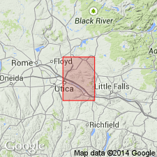
Typical exposures in ravine south of Harter Hill, located along east-central border of Utica quadrangle, central NY.
Source: US geologic names lexicon (USGS Bull. 1200, p. 1689).
For more information, please contact Nancy Stamm, Geologic Names Committee Secretary.
Asterisk (*) indicates published by U.S. Geological Survey authors.
"No current usage" (†) implies that a name has been abandoned or has fallen into disuse. Former usage and, if known, replacement name given in parentheses ( ).
Slash (/) indicates name conflicts with nomenclatural guidelines (CSN, 1933; ACSN, 1961, 1970; NACSN, 1983, 2005, 2021). May be explained within brackets ([ ]).