The National Geologic Map Database is migrating to a new infrastructure. We apologize for any service disruptions during this process.
|
|---|


- Usage in publication:
-
- Harold formation*
- Modifications:
-
- Original reference
- Mapped 1:24k
- Dominant lithology:
-
- Gravel
- Sand
- Silt
- Clay
- AAPG geologic province:
-
- Coastal basins
Summary:
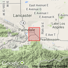
Harold formation. Well-stratified variable sequence of interbedded deposits; gravel, coarse arkosic sand with pink feldspar, in part lime-cemented and resembling travertine; buff sand and silt; whitish nodular marly clay in lower part of formation; brown gypsiferous clay beds locally at base of formation wherever it overlies gypsiferous Anaverde formation. Thickness generally 100 feet or less, 200 feet in some areas, but top is eroded. In some areas not easily differentiated from Nadeau gravel (new). Age is late Pleistocene(?).
Type locality: hills 0.5 mi southwest of San Andreas fault and 1 mi southeast of Harold Siding on Southern Pacific RR, southern CA.
Source: US geologic names lexicon (USGS Bull. 1200, p. 1680-81).
- Usage in publication:
-
- Harold formation*
- Modifications:
-
- Mapped 1:24k
- AAPG geologic province:
-
- Coastal basins
Summary:
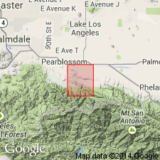
Harold formation. Described in Valyermo quadrangle where it underlies Shoemaker gravel (new). Formation gently folded; most dips less than 20 deg. Age is late Pleistocene(?).
Source: US geologic names lexicon (USGS Bull. 1200, p. 1680-81).
For more information, please contact Nancy Stamm, Geologic Names Committee Secretary.
Asterisk (*) indicates published by U.S. Geological Survey authors.
"No current usage" (†) implies that a name has been abandoned or has fallen into disuse. Former usage and, if known, replacement name given in parentheses ( ).
Slash (/) indicates name conflicts with nomenclatural guidelines (CSN, 1933; ACSN, 1961, 1970; NACSN, 1983, 2005, 2021). May be explained within brackets ([ ]).