The National Geologic Map Database is migrating to a new infrastructure. We apologize for any service disruptions during this process.
|
|---|


- Usage in publication:
-
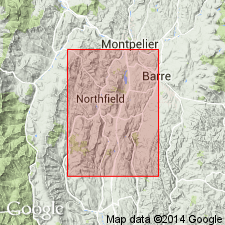
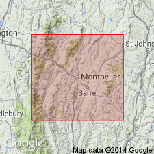
- Harlow Bridge quartzite member
- Modifications:
-
- Named
- Dominant lithology:
-
- Quartzite
- Schist
- AAPG geologic province:
-
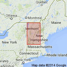
- New England province
Summary:
Named the Harlow Bridge quartzite member of the Cram Hill formation for Harlow Bridge railroad bridge, near Northfield, Washington Co., central VT. Consists of buff to pale-green platy to massive quartzite beds with intercalated siliceous schists. Unit is basal member of formation. Thickness is approximately 300 to 800 feet. Overlies unnamed Ordovician(?) schists. The Harlow Bridge is of Middle Ordovician age.
Source: GNU records (USGS DDS-6; Reston GNULEX).
- Usage in publication:
-
- Harlow Bridge quartzite member
- Modifications:
-
- Revised
- AAPG geologic province:
-
- New England province
Summary:
Revised the Harlow Bridge quartzite member as part of the Missisquoi formation since the Cram Hill was reduced in rank as part of the Missisquoi. The Harlow Bridge consists of buff to pale-green quartzite interbedded with quartz-sericite-chlorite phyllite. Overlies the Moretown member and underlies the Cram Hill member.
Source: GNU records (USGS DDS-6; Reston GNULEX).
- Usage in publication:
-
- Harlow Bridge Quartzite
- Modifications:
-
- Revised
- AAPG geologic province:
-
- New England province
Summary:
Raised the rank of the Harlow Bridge to the Harlow Bridge Quartzite through remapping of members of the Missisquoi Formation of Doll and others (1961). Consists of massive, buff-weathering beds of pale green quartzite that contains interbeds of green-gray phyllite. Unit is in fault contact with the Dog River and Moretown Formations.
Source: GNU records (USGS DDS-6; Reston GNULEX).
For more information, please contact Nancy Stamm, Geologic Names Committee Secretary.
Asterisk (*) indicates published by U.S. Geological Survey authors.
"No current usage" (†) implies that a name has been abandoned or has fallen into disuse. Former usage and, if known, replacement name given in parentheses ( ).
Slash (/) indicates name conflicts with nomenclatural guidelines (CSN, 1933; ACSN, 1961, 1970; NACSN, 1983, 2005, 2021). May be explained within brackets ([ ]).