The National Geologic Map Database is migrating to a new infrastructure. We apologize for any service disruptions during this process.
|
|---|


- Usage in publication:
-
- Hardy Hill quartzite member
- Modifications:
-
- Principal reference
- Dominant lithology:
-
- Quartzite
- Conglomerate
- Schist
- AAPG geologic province:
-
- New England province
Summary:
Pg. 132-133; C.A. Chapman and others, 1938, Geol. map and structure sections of Mascoma quadrangle, New Hampshire, scale 1:62,500; J.B. Hadley and others, 1938, Geol. map and structure sections of New Hampshire portion of Mt. Cube quadrangle, New Hampshire Hwy. Dept., scale 1:62,500.
Hardy Hill quartzite member of Orfordville formation. Gray to white quartzite and quartz conglomerate with some quartz-mica schist and mica schist. Outcrops are discontinuous. Maximum thickness 250 feet. Occurs in middle of black schists near top of formation, above Post Pond volcanic member and below Sunday Mountain volcanic member (both new). Age is Middle Ordovician(?).
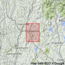
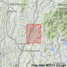
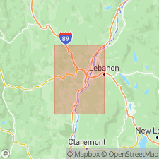
[Type locality]: about 2 mi northeast of Lebanon along Hardy Hill Brook, northwestern corner of Mascoma 15-min quadrangle, Grafton Co., northwestern NH.
Source: Publication; US geologic names lexicon (USGS Bull. 1200, p. 1674-1675).
- Usage in publication:
-
- Hardy Hill quartzite member
- Modifications:
-
- Areal extent
- AAPG geologic province:
-
- New England province
Summary:
Pg. 12, 15. Hardy Hill quartzite member of Orfordville formation. Geographically extended into Orange County, eastern Vermont. Age is Ordovician.
Source: US geologic names lexicon (USGS Bull. 1200, p. 1674-1675).
- Usage in publication:
-
- Hardy Hill quartzite member
- Modifications:
-
- Areal extent
- AAPG geologic province:
-
- New England province
Summary:
Pg. 108 (fig. 2), 113, 114, 116, pl. 1 (geol. map). Hardy Hill quartzite member of Orfordville formation. Recognized east of the Ammonoosuc thrust (in eastern part of Hanover 15-min quadrangle, Grafton County, New Hampshire). Is a discontinuous thin quartzite and quartz metaconglomerate. Maximum thickness 350 feet. Stratigraphic position revised; lies in lower part of formation below the Post Pond volcanic member. [On p. 108 (fig. 2) age is considered Middle Ordovician(?); on pl. 1 (geol. map) age is considered Ordovician(?).]
Source: Publication; US geologic names lexicon (USGS Bull. 1200, p. 1674-1675).
For more information, please contact Nancy Stamm, Geologic Names Committee Secretary.
Asterisk (*) indicates published by U.S. Geological Survey authors.
"No current usage" (†) implies that a name has been abandoned or has fallen into disuse. Former usage and, if known, replacement name given in parentheses ( ).
Slash (/) indicates name conflicts with nomenclatural guidelines (CSN, 1933; ACSN, 1961, 1970; NACSN, 1983, 2005, 2021). May be explained within brackets ([ ]).