The National Geologic Map Database is migrating to a new infrastructure. We apologize for any service disruptions during this process.
|
|---|


- Usage in publication:
-
- Hanover pebble bed
- Modifications:
-
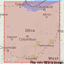
- Areal extent
- AAPG geologic province:
-
- Appalachian basin
Summary:
Pg. 98. †Hanover pebble bed in Cuyahoga formation. Name applied by Hyde in 1910 manuscript to Mississippian unit now termed Berne member of Cuyahoga formation. Described as thin pebble bed capping massive conglomerates of Toboso conglomerate province of the Cuyahoga. In Licking County, south-central Ohio, can be traced westward to beyond Newark where it overlies Cuyahoga shales of Granville province. Bed cannot be traced from outcrop to outcrop in Hocking Valley area.
Named from exposures near Hanover, Licking Co., south-central OH.
Source: US geologic names lexicon (USGS Bull. 1200, p. 1666).
For more information, please contact Nancy Stamm, Geologic Names Committee Secretary.
Asterisk (*) indicates published by U.S. Geological Survey authors.
"No current usage" (†) implies that a name has been abandoned or has fallen into disuse. Former usage and, if known, replacement name given in parentheses ( ).
Slash (/) indicates name conflicts with nomenclatural guidelines (CSN, 1933; ACSN, 1961, 1970; NACSN, 1983, 2005, 2021). May be explained within brackets ([ ]).