The National Geologic Map Database is migrating to a new infrastructure. We apologize for any service disruptions during this process.
|
|---|


- Usage in publication:
-
- Hannibal shales
- Modifications:
-
- Original reference
- Dominant lithology:
-
- Shale
- Sandstone
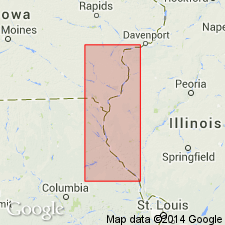
- AAPG geologic province:
-
- Lincoln anticline
- Ozark uplift
- Iowa shelf
Summary:
Pg. 289. Hannibal shales. Fossiliferous shales, 70 to 100 feet thick; upper portion sandy in places and often forms rather compact shaly sandstone; lower portion bluish or greenish clay shales. Equivalent of Vermicular shales of Swallow. Underlies Chouteau limestone and overlies Louisiana limestone. All included in Kinderhook group. Age is Mississippian.
[GNC remark (ca. 1925, US geologic names lexicon, USGS Bull. 896, p. 907): This continued for many years to be definition of Hannibal shale.]
Source: US geologic names lexicon (USGS Bull. 896, p. 907).
- Usage in publication:
-
- Hannibal shale
- Modifications:
-
- Revised
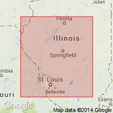
- AAPG geologic province:
-
- Illinois basin
- Lincoln anticline
Summary:
Table opp. p. 282. Hannibal shale. Showed Glen Park limestone as underlying Hannibal shale and overlying Louisiana limestone in Jersey and Calhoun Counties, southwestern Illinois, and that elsewhere (Pike County, central western Illinois, and Pike and other counties in Missouri) the Hannibal is unconformable on Louisiana limestone, the Glen Park being absent. In 1935 (Rpt. 9th Ann. Field Conf. Kansas Geol. Soc., p. 245) Moore showed Hannibal shale as present in only western Illinois and northeastern Missouri, and that in southern Illinois and southeastern Missouri the Fern Glen is unconformable on Glen Park, through absence of Chouteau limestone and Hannibal shale. Age is Early Mississippian.
Source: US geologic names lexicon (USGS Bull. 896, p. 907).
- Usage in publication:
-
- Hannibal shale
- Modifications:
-
- Revised
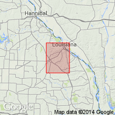
- AAPG geologic province:
-
- Lincoln anticline
Summary:
Hannibal shale. In type area in Mississippi Valley, Easley group (new) consists of Hannibal shale and Chouteau limestone and related groups or formations. Age is Early Mississippian.
Source: US geologic names lexicon (USGS Bull. 1200, p. 1664-1665).
- Usage in publication:
-
- Hannibal formation
- Modifications:
-
- Revised
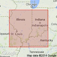
- AAPG geologic province:
-
- Iowa shelf
Summary:
Pg. 410. Hannibal formation. Lateral tracing by means of well cores and similarity of conodont assemblages indicates that Hannibal formation grades laterally into English River and Prospect Hill siltstones of Iowa. Term Hannibal has priority over English River; therefore English River and Prospect Hill are considered members of Hannibal formation. Age is Early Mississippian.
Source: US geologic names lexicon (USGS Bull. 1200, p. 1664-1665).
- Usage in publication:
-
- Hannibal shale
- Modifications:
-
- Revised
- AAPG geologic province:
-
- Iowa shelf
Summary:
Pg. 209, 210. Hannibal shale. English River siltstone and Maple Mill shale are not considered members of Hannibal shale. Age is Early Mississippian.
Source: US geologic names lexicon (USGS Bull. 1200, p. 1664-1665).
- Usage in publication:
-
- Hannibal group
- Modifications:
-
- Revised
- AAPG geologic province:
-
- Illinois basin
Summary:
Pg. 8 (fig. 1), 20-28. Hannibal group. Rank raised to group. Includes formations that lie above Louisiana limestone and beneath the Chouteau. Comprises (ascending) Glen Park siltstone, Maple Mill shale, and English River siltstone. Where the Louisiana is absent, group rests on the Saverton, and where Saverton is absent it lies on Grassy Creek shale. In small area in westernmost Illinois, McCraney formation of North Hill group overlies the Hannibal and where neither the Chouteau nor McCraney is present, the Hannibal is overlain by Osage strata. Age is Early Mississippian.
Source: US geologic names lexicon (USGS Bull. 1200, p. 1664-1665).
- Usage in publication:
-
- Hannibal formation
- Modifications:
-
- Areal extent
- AAPG geologic province:
-
- Lincoln anticline
Summary:
Pg. 9 (fig. 2), 34-39, pl. 1. Hannibal formation described in Bowling Green quadrangle where it is 90 to 121 feet thick. Composed of two lithologies: upper siltstone to fine-grained sandstone and lower silty shale. Unconformably overlies Louisiana wherever latter is present; where Louisiana is absent, formation lies unconformably on Saverton. Underlies Chouteau
formation; where Chouteau is absent, underlies Burlington formation. Age is Early Mississippian. Report includes geologic map.
Source: US geologic names lexicon (USGS Bull. 1200, p. 1664-1665).

- Usage in publication:
-
- Hannibal shale
- Modifications:
-
- Revised
- AAPG geologic province:
-
- Lincoln anticline
Summary:
Pg. 98, 99. Hannibal shale. Unconformably overlies Cuivre shale (new) in Pike County, Missouri.
Source: US geologic names lexicon (USGS Bull. 1200, p. 1664-1665).

- Usage in publication:
-
- Hannibal Shale
- Modifications:
-
- Overview
- AAPG geologic province:
-
- Illinois basin
Summary:
Hannibal Shale of New Albany Group in IL now defined as overlying "Glen Park" Formation and underlying Chouteau Limestone, both of which are absent in Hannibal type section. Widely exposed in valley of Mississippi and Illinois Rivers in western IL. Extends eastward in subsurface across IL. In McCraney Co., Hannibal is almost entirely green to gray, argillaceous siltstone in northern part of outcrop area. Lower part becomes increasingly argillaceous southward and consists of silty shale in Calhoun and Jersey Cos. In southern part of outcrop area, contains Nutwood Shale Member, a lens of black shale as much as 40 ft thick. A siltstone facies formerly called English River Formation is well developed in upper part of Hannibal in Adams and Hancock Cos. Hannibal contains abundant conodonts which show upper part of formation is equivalent to Chouteau Limestone in area where Chouteau and North Hill Group are absent. Megafossils are scarce but brachiopod CHONOPECTUS is abundant in siltstone facies. "Roostertail" markings (TAONURUS CAUDAGALLI) and irregular tabular markings (SCALARITUBA MISSOURIENSIS) are common features.
Source: GNU records (USGS DDS-6; Reston GNULEX).
- Usage in publication:
-
- Hannibal Shale
- Modifications:
-
- Overview
- AAPG geologic province:
-
- Illinois basin
Summary:
In IL, the Hannibal consists of highly bioturbated, nonlaminated, organic-poor, greenish- to dark-greenish-gray mudstone and shale. Argillaceous siltstone beds are abundant in the upper part of the formation. The Nutwood Member of the Hannibal is a thin (0-40 ft) silty, dark-brown to black shale in the lower part of the formation. The Hannibal reaches a maximum thickness of 110 ft in northeastern Macoupin Co. and thins to the northwest and southeast. Overlies the Louisiana Limestone at its type section and is overlain by the Burlington Limestone. Where the Horton Creek is present in IL, the Hannibal conformably overlies the Horton Creek. Age is considered Early Mississippian, though the Devonian-Mississippian boundary may be in the lower part of the formation according to Collinson and others (1971).
Source: GNU records (USGS DDS-6; Reston GNULEX).

- Usage in publication:
-
- Hannibal Shale*
- Modifications:
-
- Overview
- AAPG geologic province:
-
- Illinois basin
- Ozark uplift
Summary:
Hannibal Shale occurs in subsurface of eastern MO and western IL in St. Louis, MO, area. Consists of fissile siltstone and shale; uppermost part is very fine-grained, argillaceous sandstone.
Source: GNU records (USGS DDS-6; Reston GNULEX).
For more information, please contact Nancy Stamm, Geologic Names Committee Secretary.
Asterisk (*) indicates published by U.S. Geological Survey authors.
"No current usage" (†) implies that a name has been abandoned or has fallen into disuse. Former usage and, if known, replacement name given in parentheses ( ).
Slash (/) indicates name conflicts with nomenclatural guidelines (CSN, 1933; ACSN, 1961, 1970; NACSN, 1983, 2005, 2021). May be explained within brackets ([ ]).