

- Usage in publication:
-
- Hampshire formation
- Modifications:
-
- Named
- Dominant lithology:
-
- Sandstone
- Shale
- AAPG geologic province:
-
- Appalachian basin
Summary:
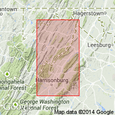
Hampshire Formation here named for county in east-central WV. Characterized by thin-bedded, relatively hard, more or less micaceous sandstones with shale intercalations. Mostly dull-red, dark gray, and brown. Thickness ranges from 1,000 ft to 1,400 ft. Underlies Pocono Sandstone; overlies Jennings Formation. Comprises representatives of the Catskill in their entirety or in greater part. Age is Late Devonian.
Source: GNU records (USGS DDS-6; Reston GNULEX).

- Usage in publication:
-
- Hampshire formation
- Modifications:
-
- Reinstated
- AAPG geologic province:
-
- Appalachian basin
Summary:
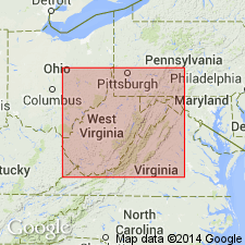
Name Hampshire formation, applied by Darton to exposure of Late Devonian redbeds in Hampshire Co. is here revived for rocks previously called "Catskill" in WV. Redbeds of Catskill Mountains in NY are of Portage and Hamilton age, while those in Appalachian region are post-Chemung. Formation is well developed along the Potomac where it attains maximum thickness of about 3,000 ft in Morgan and Hampshire Cos.; thins westward and southward. Includes red and green sandstones and shales. Underlies "Pocono facies"; overlies Chemung Formation. Name Hampshire also reinstated by the Maryland Geological Survey.
Source: GNU records (USGS DDS-6; Reston GNULEX).
- Usage in publication:
-
- Hampshire formation*
- Modifications:
-
- Areal extent
- AAPG geologic province:
-
- Appalachian basin
Summary:
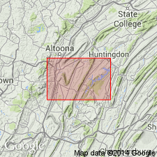
Hampshire Formation described in Hollidaysburg and Huntingdon quadrangles, PA. Thickness 2,000-2,500 ft. Underlies Pocono Formation; overlies Chemung Formation.
Source: GNU records (USGS DDS-6; Reston GNULEX).
- Usage in publication:
-
- Hampshire Group
- Modifications:
-
- Revised
- AAPG geologic province:
-
- Appalachian basin
Summary:
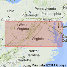
Hampshire is here raised to group status in the subsurface of north-central WV. Lower Hampshire of Lewis (1983: WV University MS thesis) is here named the Cannon Hill Formation, a sandstone-rich unit with beds of red shale. Upper Hampshire is here named the Rowlesburg Formation, a nonmarine, red shale and mudstone-rich interval.
Source: GNU records (USGS DDS-6; Reston GNULEX).
- Usage in publication:
-
- Hampshire Formation
- Modifications:
-
- Areal extent
- AAPG geologic province:
-
- Appalachian basin
Summary:
Hampshire Formation used for the first time in the Catawba syncline region of southwestern VA. Base of the unit is placed at the base of a 7.0-m redbed overlying the Blizzard Member of the Foreknobs Formation. Strata have been included previously in the Chemung by other workers. Underlies Price Formation.
Source: GNU records (USGS DDS-6; Reston GNULEX).
For more information, please contact Nancy Stamm, Geologic Names Committee Secretary.
Asterisk (*) indicates published by U.S. Geological Survey authors.
"No current usage" (†) implies that a name has been abandoned or has fallen into disuse. Former usage and, if known, replacement name given in parentheses ( ).
Slash (/) indicates name conflicts with nomenclatural guidelines (CSN, 1933; ACSN, 1961, 1970; NACSN, 1983, 2005, 2021). May be explained within brackets ([ ]).