The National Geologic Map Database is migrating to a new infrastructure. We apologize for any service disruptions during this process.
|
|---|


- Usage in publication:
-
- Halgaito tongue*
- Modifications:
-
- Original reference
- Dominant lithology:
-
- Sandstone
- Shale
- AAPG geologic province:
-
- Paradox basin
Summary:
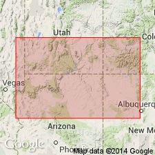
Pg. 1420, 1423, 1424, 1441, 1443, 1446. Halgaito tongue of Cutler formation [also Halgaito member]. Red sandstones and sandy shale, 0 to 430 feet thick, forming basal part of Cutler formation in southern part of San Juan County, southeastern Utah, and northeastern Arizona. Underlies Cedar Mesa sandstone member of Cutler and overlies Rico formation. In earlier reports called Supai(?) formation. Age is Permian.
Well exposed near Halgaito Spring, southwest of Mexican Hat (Bluff PO), UT, but btw. Lees Ferry and Kayenta, northeastern AZ.
Source: US geologic names lexicon (USGS Bull. 896, p. 897).
- Usage in publication:
-
- Halgaito formation
- Modifications:
-
- Revised
- AAPG geologic province:
-
- Paradox basin
- Black Mesa basin
Summary:
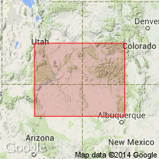
Cutler formation raised in stratigraphic rank to Cutler group and divided into (ascending): Rico transitional facies, Halgaito formation, and Cedar Mesa formation. Rico in this classification becomes an informal unit that represents the change from marine to nonmarine sequence in which the Pennsylvanian-Permian boundary lies. The uppermost gray marine limestone near the base of the Cutler is the top of the Rico facies. Cross sections, columnar sections, isopach maps, correlation chart. Halgaito and Cedar Mesa, though raised in stratigraphic rank in this paper, are not discussed. Halgaito shown in southeast UT in the Paradox basin and adjoining northeast AZ in the Black Mesa basin. Assigned a Virgil or Late Pennsylvanian and Wolfcamp or Early Permian age.
Source: GNU records (USGS DDS-6; Denver GNULEX).
For more information, please contact Nancy Stamm, Geologic Names Committee Secretary.
Asterisk (*) indicates published by U.S. Geological Survey authors.
"No current usage" (†) implies that a name has been abandoned or has fallen into disuse. Former usage and, if known, replacement name given in parentheses ( ).
Slash (/) indicates name conflicts with nomenclatural guidelines (CSN, 1933; ACSN, 1961, 1970; NACSN, 1983, 2005, 2021). May be explained within brackets ([ ]).