

- Usage in publication:
-
- Guye formation*
- Modifications:
-
- Original reference
- Dominant lithology:
-
- Shale
- Sandstone
- Grit
- Slate
- Conglomerate
- AAPG geologic province:
-
- Puget Sound province
- Eastern Columbia basin
Summary:
Guye formation. Shales, sandstones, grits, slate, and conglomerates with a little limestone and chert, and with interbedded basalt and rhyolite flows. Thickness 0 to 3,500 feet. Not found in contact with other Miocene sedimentary formations (Ellensburg). Flora (identified by F.H. Knowlton) indicates probable Miocene age. Unconformably overlain by Keechelus volcanics.
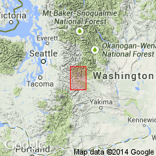
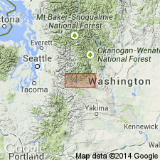
Well exposed on Guye Creek. Known only in northwest quarter of Snoqualmie quadrangle, [King and Kittitas Cos.], central WA.
Source: US geologic names lexicon (USGS Bull. 1200, p. 892).
- Usage in publication:
-
- Guye formation*
- Modifications:
-
- Revised
- Age modified
- AAPG geologic province:
-
- Puget Sound province
- Eastern Columbia basin
Summary:
Pg. 101 (table 1), 111-113. Guye formation. Name was applied by Smith and Calkins to heterogeneous group of sedimentery and volcanic rocks whose structure was not clearly known. As a result, rocks of several ages were included in the formation. This composite unit erroneously dated Miocene from small collection of fossil leaves, although Smith and Calkins and most later workers realized that the rock types and structure resembled lower Tertiary rocks more closely than Miocene. Because the Guye was one of the few dated units in region, its age was used to date more widespread formations. Guye formation of Smith and Calkins here separated into four formations: Denny (new), Guye (restricted), Mount Catherine rhyolite (new), and Naches. Exposure south from Snoqualmie Pass is bounded on three sides by Mount Catherine rhyolite which dips away from the Guye on all sides and apparently unconformably overlies it. Structure interpreted as anticline in the rhyolite with homoclinal Guye exposed in core. On Chair Mountain, overlies bedded chert of the Denny formation. On Denny Mountain, underlies Keechelus andesite, apparently unconformably. Locally intruded by Snoqualmie granodiorite. Formation is thick sequence of shale, sandstone, and conglomerate; fluvatile origin shown by lenses of conglomerate that are interbedded with sandstone and leaf-bearing shale. Conglomerate, sandstone, and shale are mixed in all proportions; beds or lenses range from thin to massive. Conglomerate, percentage-wise is the least important rock type but is the most distinctive. Thickness about 5,000 feet. Paleobotanic evidence (fossil leaves identified by R.W. Brown) and stratigraphic relationships suggest and Eocene or Paleocene age.
Type area (Guye restricted): along Coal Creek and its tributaries, on east side of Snoqualmie Pass. Area almost parallels strike; hence, stratigraphic exposure is limited to northwest and south of Snoqualmie Pass, [King and Kittitas Cos., central WA]. Named from exposures on Guye Creek.
Source: US geologic names lexicon (USGS Bull. 1200, p. 1637-1638); GNU records (USGS DDS-6; Menlo GNULEX).
- Usage in publication:
-
- Guye Sedimentary Member*
- Modifications:
-
- Revised
- AAPG geologic province:
-
- Puget Sound province
- Eastern Columbia basin
Summary:
Guye Sedimentary Member is reduced in rank from formation (Smith and Calkins, 1906; Foster, 1960) and designated as the lowermost member of the Naches Formation. Characterized by fluviatile, leaf-bearing argillite, interbedded with dark sandstone and chert-rich conglomerate. Overlain by and intruded with Mount Catherine Rhyolite Member (new) and "other rocks typical of the lower part of the Naches Formation." Shown as middle Eocene on correlation chart.
Source: GNU records (USGS DDS-6; Menlo GNULEX).
- Usage in publication:
-
- Guye Sedimentary Member*
- Modifications:
-
- Age modified
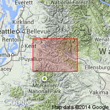
- Areal extent
- AAPG geologic province:
-
- Cascades province
Summary:
Guye Sedimentary Member of the Naches Formation is geographically extended into the report area. Age is revised from Eocene to: middle and late Eocene (based on radiometric data).
Source: GNU records (USGS DDS-6; Menlo GNULEX).
For more information, please contact Nancy Stamm, Geologic Names Committee Secretary.
Asterisk (*) indicates published by U.S. Geological Survey authors.
"No current usage" (†) implies that a name has been abandoned or has fallen into disuse. Former usage and, if known, replacement name given in parentheses ( ).
Slash (/) indicates name conflicts with nomenclatural guidelines (CSN, 1933; ACSN, 1961, 1970; NACSN, 1983, 2005, 2021). May be explained within brackets ([ ]).