

- Usage in publication:
-
- Gulfport Formation
- Modifications:
-
- Named
- Dominant lithology:
-
- Sand
- AAPG geologic province:
-
- Mid-Gulf Coast basin
Summary:
Gulfport Formation, here named in Harrison Co., southeastern MS, described as barrier ridge composed of white, medium- to fine-grained sand, yellow-orange near surface. Thickness ranges form 5.0 to 9.5 m. Overlies Biloxi Formation. Age is late Pleistocene.
Source: GNU records (USGS DDS-6; Reston GNULEX).
- Usage in publication:
-
- Gulfport Formation
- Modifications:
-
- Overview
- Areal extent
- AAPG geologic province:
-
- Mid-Gulf Coast basin
Summary:
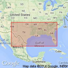
Gulfport Formation is limited to a 1- to 3-km-wide discontinuous barrier ridge belt that borders the Gulf mainland shore. Commonly overlies Prairie Formation (alluvium) landward and Biloxi Formation (shelf deposits) near shore. Grades upward from poorly to moderately sorted shoreface sands to foreshore sand and dunes. Fig. 1 shows unit extending from Gulfport, MS, eastward to the mouth of the Ochlockonee River, Franklin Co., FL. Deposited during the Sangamonian.
Source: GNU records (USGS DDS-6; Reston GNULEX).
- Usage in publication:
-
- Gulfport Formation*
- Modifications:
-
- Areal extent
- AAPG geologic province:
-
- Mid-Gulf Coast basin
GNU Staff, 1995, Draft copy of Otvos, E.G., Mississippi Gulf Coast; geologic evolution, stratigraphy, coastal geomorphology, and Gulf-wide Pleistocene correlations, USGS Bull. XXXX (unpublished): U.S. Geological Survey Digital Data Series, DDS-6, 1 CD-ROM., release 3
Summary:
Pleistocene Gulfport Formation occurs in MS.
Source: GNU records (USGS DDS-6; Reston GNULEX).
For more information, please contact Nancy Stamm, Geologic Names Committee Secretary.
Asterisk (*) indicates published by U.S. Geological Survey authors.
"No current usage" (†) implies that a name has been abandoned or has fallen into disuse. Former usage and, if known, replacement name given in parentheses ( ).
Slash (/) indicates name conflicts with nomenclatural guidelines (CSN, 1933; ACSN, 1961, 1970; NACSN, 1983, 2005, 2021). May be explained within brackets ([ ]).