The National Geologic Map Database is migrating to a new infrastructure. We apologize for any service disruptions during this process.
|
|---|


- Usage in publication:
-
- Grizzly Peak rhyolite
- Modifications:
-
- Original reference
- Dominant lithology:
-
- Rhyolite
- AAPG geologic province:
-
- Eagle basin
Summary:
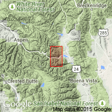
Grizzly Peak rhyolite. Gray fine-grained, easily weathered rock in which are embedded innumberable fragments of gneiss, schist, and other older rocks. Color light gray to brown. Texture that of rhyolite porphyry to pitchstone. In absence of conclusive evidence it seems fairly safe to consider this rhyolite to be of Tertiary (Eocene?) age. [Map shows Grizzly Peak, Chaffee Co., central CO, in midst of this mass of rhyolite. (Exposed also in Lake Co.)]
[Grizzly Peak (13, 970 ft elev.) along Continental Divide, north of Garfield Peak and Red Mountain, Lat. 39 deg. 02 min. 33 sec. N., Long. 106 deg. 35 min. 51 sec. W., in sec. 31, T. 11 S., R. 82 W., and sec. 6, T. 12 S., R. 82 W., Chaffee-Pitkin Co. line, Independence Pass 7.5-min quadrangle (1998 ed.), central CO (USGS GNIS database, USGS historical topographic map collection TopoView; accessed February 15, 2013, my little brother's 45th birthday).]
Source: US geologic names lexicon (USGS Bull. 896, p. 882).
- Usage in publication:
-
- Grizzly Peak rhyolite†
- Modifications:
-
- Abandoned
- AAPG geologic province:
-
- Eagle basin
Stark, J.T., and Barnes, F.F., 1935, Geology of the Sawatch Range, Colorado: Colorado Scientific Society Proceedings, v. 13, no. 8, p. 467-479, (incl. geologic map)
Summary:
Pg. 477, map. †Grizzly Peak rhyolite discarded to avoid confusion with a mountain of that name several miles to south. Howell's Grizzly Peak and Red Mountain rhyolites included in their Grizzly Mountain rhyolite.
[These rocks are now included in Grizzly Peak Tuff (see entry under Fridrich and others, 1991).]
Source: US geologic names lexicon (USGS Bull. 896, Grizzly Mountain entry p. 882).
- Usage in publication:
-
- Grizzly Peak Tuff
- Modifications:
-
- Areal extent
- AAPG geologic province:
-
- Eagle basin
Summary:
The Grizzly Peak cauldron which covered a 17 x 23 km area was the source of the 34 m.y. Grizzly Peak Tuff. The cauldron extends from Independence Pass to northern Taylor Park in the Sawatch Range, Pitkin and Lake Cos, CO, Eagle basin. Geologic maps. The tuff, a single eruptive unit, can be zoned from high-silica rhyolite at base to quartz latite in its highest exposures.
Source: GNU records (USGS DDS-6; Denver GNULEX).
- Usage in publication:
-
- Grizzly Peak Tuff
- Modifications:
-
- Areal extent
- AAPG geologic province:
-
- Eagle basin
Summary:
Resulted from a single eruption in the Sawatch Range, CO, Eagle basin, about 34 Ma that caused the collapse of the Grizzly Peak cauldron. Outflow sheets extended at least 50 km from the cauldron; only 2 erosional remnants known. Only intracaldera tuff is preserved in the Sawatch Range. The tuff is a single cooling unit 2.7 km thick that is zoned having a high silica rhyolite near the base and low silica rhyolite near top. Type section shown in a graphic section [presumably on Grizzly Peak, though section not located] as divisible into (ascending): 1) monotonous base; 2) high silica rhyolite; 3) rhyolite; 4) lower heterogeneous tuff horizon; 5) low silica rhyolite; 6) upper heterogeneous tuff horizon. Its reconstructed volume estimated at greater than 600 cubic km. Chemical analyses.
Source: GNU records (USGS DDS-6; Denver GNULEX).
- Usage in publication:
-
- Grizzly Peak Tuff*
- Modifications:
-
- Principal reference
- AAPG geologic province:
-
- Eagle basin
Summary:
Grizzly Peak Tuff. Rhyolitic ash-flow tuff. Age is Oligocene.
Type area: Grizzly Peak area, in T. 12 S., R. 82 W., Chaffee Co., central CO.
Study area is within Chaffee Co, CO (Eagle basin) where unit has been called by several designations--Grizzly Peak Rhyolite, rhyolite of Independence Pass district, Grizzly Mountain Rhyolite. Given formal status as Grizzly Peak Tuff. All of the earlier names are herein abandoned. These rocks belong to a single cauldron cycle. Type area designated as the exposures in the Grizzly Peak area, T12S, R82W, Chaffee Co, CO in the Eagle basin. Half the ponded tuff ponded in a 17-by 23-km, >600 cubic km caldera, filling the asymmetric depression locally to >2.7, a minimum thickness as base not exposed and top is eroded. After collapse, the caldera resurged. High-silica angular to subround rhyolite lithic fragments present throughout the tuff; the fragments are more abundant near base than at top. Caldera fill has local marker beds. The tuff is compositionally zoned. Occurs as intracaldera, and outflow tuffs, breccias, and ash-flow tuff dikes and vents. Cross sections. Geologic maps. Oligocene age.
Source: GNU records (USGS DDS-6; Denver GNULEX).
For more information, please contact Nancy Stamm, Geologic Names Committee Secretary.
Asterisk (*) indicates published by U.S. Geological Survey authors.
"No current usage" (†) implies that a name has been abandoned or has fallen into disuse. Former usage and, if known, replacement name given in parentheses ( ).
Slash (/) indicates name conflicts with nomenclatural guidelines (CSN, 1933; ACSN, 1961, 1970; NACSN, 1983, 2005, 2021). May be explained within brackets ([ ]).