The National Geologic Map Database is migrating to a new infrastructure. We apologize for any service disruptions during this process.
|
|---|


- Usage in publication:
-
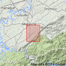
- Greasy Cove formation*
- Modifications:
-
- Named
- Dominant lithology:
-
- Limestone
- Shale
- Sandstone
- AAPG geologic province:
-
- Appalachian basin
Summary:
Named the Greasy Cove formation for Greasy Cove, Blount Co., eastern TN. Consists of gray argillaceous limestone (40 percent), red shale and fine-grained sandstone (10 percent), gray shale and siltstone (25 percent), and gray fine-grained sandstone (25 percent), all interbedded. Thickness is at least 400 feet, top faulted. Overlies the Grainger formation. Name replaces Newman limestone. The Greasy Cove is of Late Mississippian age.
Source: GNU records (USGS DDS-6; Reston GNULEX).
For more information, please contact Nancy Stamm, Geologic Names Committee Secretary.
Asterisk (*) indicates published by U.S. Geological Survey authors.
"No current usage" (†) implies that a name has been abandoned or has fallen into disuse. Former usage and, if known, replacement name given in parentheses ( ).
Slash (/) indicates name conflicts with nomenclatural guidelines (CSN, 1933; ACSN, 1961, 1970; NACSN, 1983, 2005, 2021). May be explained within brackets ([ ]).