

- Usage in publication:
-
- Gray Mesa member*
- Modifications:
-
- Original reference
- Dominant lithology:
-
- Limestone
- Shale
- Sandstone
- AAPG geologic province:
-
- Orogrande basin
- San Juan basin
Summary:
Gray Mesa member of Madera limestone. Thick- to thin-bedded, predominantly cherty and gray to dark-gray ledgy limestone with minor amount of gray shale and gray to brown fine- to coarse-grained sandstone. Thickness 850 to 900 feet. [Is basal member of Madera limestone.] Conformably underlies Atrasado member (new); conformably overlies Sandia formation. Age is Pennsylvanian.
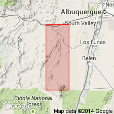
Extends in continuous outcrop from Comanche Arroyo [Arroyo Comanche] along steep east face of Gray Mesa and southward past Monte de Belen. Another belt extends from Red Tanks Arroyo near Saladito Ranch southeastward into west slopes of Ladron Mountains. Most completely exposed section lies in steep east face of Monte de Belen, Socorro and Valencia Cos., west-central NM. [Probably named from excellent exposures along Gray Mesa [now Mesa Aparejo], Valencia Co., west-central NM.]
Source: US geologic names lexicon (USGS Bull. 1200, p. 1587).
- Usage in publication:
-
- Gray Mesa Limestone
- Modifications:
-
- Revised
Kues, B.S., 2001, The Pennsylvanian System in New Mexico; Overview with suggestions for revisions of stratigraphic nomenclature: New Mexico Bureau of Geology and Mineral Resources, New Mexico Geology, v. 23, no. 4, p. 103-122.
Summary:
Pg. 106-107 (fig. 3, strat. chart). Gray Mesa Limestone of Madera Group. Previously a member of Madera Limestone of Magdalena Group in Lucero Mesa area, central New Mexico [author recommends use of Magdalena Group be discarded]. Now recognized in several areas along the Rio Grande. Replaces Los Moyos Limestone of Madera Group of Manzano Mountains, Nakaye Formation of Magdalena Group of Caballo Mountains, and informal gray limestone member of Madera Limestone of central and central northern New Mexico. Overlies Sandia Formation or Red House Formation. In central northern New Mexico (Nacimiento and Jemez Mountains) underlies Atrasado Formation of Madera Group. To south (Socorro area, Lucero uplift, and Los Pinos, Manzano, Manzanita, and Sandia Mountains) underlies Atrasado Formation of Madera Group. In southwestern New Mexico (Robledo, Mud Springs, Caballo, and Fra Cristobal Mountains, and Sierra Oscura) underlies Atrasado Formation or Bar B Formation of Madera Group. Age is late Middle Pennsylvanian (Desmoinesian); locally in Nacimiento and Jemez Mountains, age is Middle Pennsylvanian (Atokan to Desmoinesian).
Source: Publication.
- Usage in publication:
-
- Gray Mesa Formation
- Modifications:
-
- Principal reference
- Dominant lithology:
-
- Limestone
- Shale
- Sandstone
- Conglomerate
- AAPG geologic province:
-
- San Juan basin
Krainer, Karl, and Lucas, S.G., 2004, Type sections of the Pennsylvanian Gray Mesa and Atrasado Formations, Lucero uplift, central New Mexico: New Mexico Museum of Natural History and Science Bulletin, no. 25, p. 7-30.
Summary:
Pg. 10-11 (fig. 4), 12-18, 28+ (measured sections). Gray Mesa Formation. Highly fossiliferous limestones, and a few beds of shale, sandstone, and conglomerate; separated by several meters of covered intervals. Subdivided into: an upper member, 138 m thick; middle member, 65 m thick; and lower member, 185.5 m thick, which contains abundant CHAETETES. Total thickness about 388 m. Underlies Atrasado Formation. Rests on Sandia Formation, contact placed at base of lowest cherty limestone above the coarse-grained, pebbly, bright reddish to brownish sandstone of the Sandia. Age is considered Middle Pennsylvanian (mostly Desmoinesian), based on fusulinids. Type section [principal reference section] designated.
[Principal reference section]: measured on east-facing escarpment of Mesa Aparejo [formerly known as Gray Mesa], in SE/4 sec. 14, T. 5 N., R. 3 W.; base at UTM Zone 13s, 306,245 m E., 3,836,323 m N., top at UTM Zone 13s, 305,539 m E., 3,836,685 m N., [approx. Lat. 34 deg. 39 min. 17 sec. N., Long. 107 deg. 07 min. 15 sec. W., southwestern corner Mesas Mojinas 7.5-min quadrangle], Valencia Co., central NM.
[Additional locality information from USGS historical topographic map collection TopoView; accessed May 18, 2018.]
Source: Publication.
For more information, please contact Nancy Stamm, Geologic Names Committee Secretary.
Asterisk (*) indicates published by U.S. Geological Survey authors.
"No current usage" (†) implies that a name has been abandoned or has fallen into disuse. Former usage and, if known, replacement name given in parentheses ( ).
Slash (/) indicates name conflicts with nomenclatural guidelines (CSN, 1933; ACSN, 1961, 1970; NACSN, 1983, 2005, 2021). May be explained within brackets ([ ]).