

- Usage in publication:
-
- Granite Park
- member
- Modifications:
-
- First used
- Dominant lithology:
-
- Limestone
- Argillite
- Conglomerate
- AAPG geologic province:
-
- Northern Rocky Mountain region
Summary:
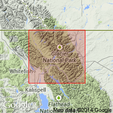
First published use as a geologic name. Intent to name not stated. No type locality designated. Location of "Granite Park" not shown on map. Assigned as upper member of Siyeh formation in Glacier National Park, MT in Northern Rocky Mountain region, and in Waterton Lakes National Park, AT. [Not possible to determine exact areal extent.] Is a unit 185 ft thick composed of gray, thin-bedded limestone with argillite and limestone pebble conglomerate interbeds. Oolitic in lower part. Upper part has large colonies of algae COLLENIA. Well exposed along Garden Wall near Granite Park. Fully developed in Hole-in-the-Wall cirque. Overlies COLLENIA? FREQUENS zone of Siyeh. Underlies Hole-in-the-Wall member (first used) of Boulder Pass formation (not used).
Source: GNU records (USGS DDS-6; Denver GNULEX).

- Usage in publication:
-
- Granite Park member
- Modifications:
-
- Revised
- Overview
- AAPG geologic province:
-
- Northern Rocky Mountain region
Summary:
Is upper member, one of four divisions of Siyeh formation of Piegan group (new) of Belt series. Overlies COLLENIA FREQUENS zone of Siyeh. Underlies Spokane formation of Piegan. Type locality stated as being on the eastern slope of Swiftcurrent Pass on Granite Park trail. Type locality stated as being on cliffs of the continental divide southeastward from Granite Park, Glacier National Park, MT in Northern Rocky Mountain region, where rocks crossed by trail to dike above Grinnell Glacier. Well-exposed also in Hole-in-the-Wall Basin near Boulder Peak and on trail from Alderson to Carthew lakes, Waterton Lakes National Park, Canada. Ranges from 280 to 900 ft thick. Section measured in Livingston Range, near Browns Pass, Glacier National Park described. Consists of gray, greenish-gray and brown, magnesian limestone, oolite, argillite, and quartzite. Has large colonies of algae COLLENIA WILLISI at several horizons. Correlation chart. Of pre-Cambrian age.
Source: GNU records (USGS DDS-6; Denver GNULEX).
For more information, please contact Nancy Stamm, Geologic Names Committee Secretary.
Asterisk (*) indicates published by U.S. Geological Survey authors.
"No current usage" (†) implies that a name has been abandoned or has fallen into disuse. Former usage and, if known, replacement name given in parentheses ( ).
Slash (/) indicates name conflicts with nomenclatural guidelines (CSN, 1933; ACSN, 1961, 1970; NACSN, 1983, 2005, 2021). May be explained within brackets ([ ]).