The National Geologic Map Database is migrating to a new infrastructure. We apologize for any service disruptions during this process.
|
|---|


- Usage in publication:
-
- Grand Tower formation, limestone
- Modifications:
-
- Revised
- Overview
- AAPG geologic province:
-
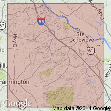
- Ozark uplift
Summary:
Revised in that Grand Tower conformably underlies newly named Beauvais formation; conformably overlies Little Saline limestone. Grand Tower has limited distribution in Ste. Genevieve Co, MO, Ozark uplift; exposed in syncline in Little Saline faulted zone and in smaller syncline to northeast; also recognized in hills south of Little Saline Creek. Maximum thickness is about 250 ft. Geologic map; measured section; stratigraphic chart; faunal list. Middle Devonian (Onondaga) age.
Source: GNU records (USGS DDS-6; Denver GNULEX).
- Usage in publication:
-
- Grand Tower Limestone
- Modifications:
-
- Overview
- Areal extent
- AAPG geologic province:
-
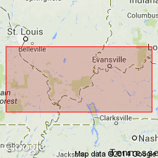
- Illinois basin
Summary:
Grand Tower Limestone is composed of four lithofacies: Dutch Creek Sandstone Member (at base), laterally time-equivalent Geneva Dolomite Member (to the north) and bioclastic facies (to the south), and an unnamed laminated dolomite (equivalent to Vernon Fork Member in IN). "Tioga" Bentonite Bed is present in upper part in some areas. Dutch Creek is time-transgressive--early Eifelian in southwestern IL and late Emsian in southeastern IL, based on conodonts. Section at Belgique, MO, here recognized as Grand Tower, has been previously mapped as St. Laurent by Weller and St. Clair (1928) and by Amos (1986).
Source: GNU records (USGS DDS-6; Reston GNULEX).
For more information, please contact Nancy Stamm, Geologic Names Committee Secretary.
Asterisk (*) indicates published by U.S. Geological Survey authors.
"No current usage" (†) implies that a name has been abandoned or has fallen into disuse. Former usage and, if known, replacement name given in parentheses ( ).
Slash (/) indicates name conflicts with nomenclatural guidelines (CSN, 1933; ACSN, 1961, 1970; NACSN, 1983, 2005, 2021). May be explained within brackets ([ ]).