

- Usage in publication:
-
- Grand Pitch Formation*
- Modifications:
-
- Named
- Dominant lithology:
-
- Quartzite
- Slate
- AAPG geologic province:
-
- New England province
Summary:
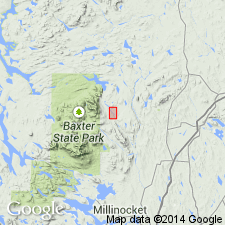
Named for Grand Pitch of East Branch of Penobscot River. Penobscot Co., northeastern ME. Name replaces Grand Falls Formation of Ruedemann and Smith (1935); name was preoccupied. Continuous exposure lines riverbanks for 1000 ft in vicinity of Grand Pitch. At type section, consists of light-greenish-gray, fine-grained quartzite in massive beds interbedded with thinner layers of light-greenish-gray and medium gray slate; and red slate containing OLDHAMIA SMITHI Ruedemann. Proportions of slate increase both upstream and downstream. Age is Cambrian(?); may be as old as late Precambrian and as young as Early Ordovician.
Source: GNU records (USGS DDS-6; Reston GNULEX).
- Usage in publication:
-
- Grand Pitch Formation*
- Modifications:
-
- Age modified
- AAPG geologic province:
-
- New England province
Summary:
Used as Grand Pitch Formation of Early Cambrian(?) age. Age follows usage of Neuman (1967, USGS Professional Paper 524-I).
Source: GNU records (USGS DDS-6; Reston GNULEX).
For more information, please contact Nancy Stamm, Geologic Names Committee Secretary.
Asterisk (*) indicates published by U.S. Geological Survey authors.
"No current usage" (†) implies that a name has been abandoned or has fallen into disuse. Former usage and, if known, replacement name given in parentheses ( ).
Slash (/) indicates name conflicts with nomenclatural guidelines (CSN, 1933; ACSN, 1961, 1970; NACSN, 1983, 2005, 2021). May be explained within brackets ([ ]).