

- Usage in publication:
-
- Grand Island formation
- Modifications:
-
- Original reference
- AAPG geologic province:
-
- Salina basin
Summary:
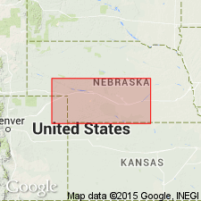
Pg. 190. Grand Island formation (Kansan), 50 to 100+ feet thick, lies unconformably on Fullerton bed, and is conformably overlain by Upland formation (Yarmouth).
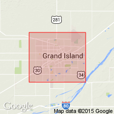
Named from exposures at and around Grand Island, Hall Co., southeastern NE.
Source: US geologic names lexicon (USGS Bull. 896, p. 853).
- Usage in publication:
-
- Grand Island formation
- Modifications:
-
- Areal extent
- Dominant lithology:
-
- Sand
- Gravel
Summary:
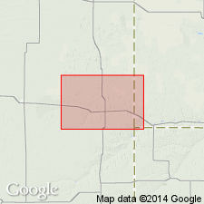
Pg. 326, 343-346. Grand Island formation. Largely fluvial inwash-outwash deposits of sand and gravel, fine and coarse, of Kansan age (Pleistocene). Thickness 30 to 150 feet. Upper 30 to 50 feet are usually fine sand. In a section northwest of Holdrege it is 120 feet thick, and upper 100 feet is clean fine to medium sand and lower 20 feet is mixed sand and gravel. Extends continuously under Platte River Valley and plains to north and south, covering 15,000+/- sq mi.
Source: US geologic names lexicon (USGS Bull. 896, p. 853).
- Usage in publication:
-
- Grand Island member
- Modifications:
-
- Revised
Summary:
Pg. 520 (fig. 3), 521, 522; R.C. Moore and others, 1951, Kansas Geol. Survey Bull., no. 89, p. 15. Grand Island member of Meade formation. Lower member of Meade formation in Kansas. Underlies Sappa member. Thickness commonly 25 feet. Age is Pleistocene (late Kansan).
Source: US geologic names lexicon (USGS Bull. 1200, p. 1566).
- Usage in publication:
-
- Grand Island sand and gravel formation
- Modifications:
-
- Revised
- AAPG geologic province:
-
- Iowa shelf
Summary:
Pg. 12 (fig. 6). Grand Island sand and gravel formation. Correlation table shows relation of Nebraska Pleistocene formations to continental glaciations on cyclic basis involving erosion, alluviation, eolation, and soil formation. Grand Island sand and gravel (Kansan) divided into "Upper Grand Island" and "Lower Grand Island." Thickness of Upper Grand Island about 28 feet in Little Sioux Valley, near Harrison-Monona County line, Iowa.
Source: US geologic names lexicon (USGS Bull. 1200, p. 1566).
- Usage in publication:
-
- Grand Island sand and gravel formation
- Modifications:
-
- Revised
- AAPG geologic province:
-
- Iowa shelf
Summary:
Grand Island sand and gravel formation. Proposed that name Grand Island be restricted to Upper Grand Island, and name Red Cloud sand and gravel be applied to Lower Grand Island of Condra and Reed (1950), which includes pro-Kansan sand and gravel. The restricted Grand Island was deposited during retreat and waning of Kansas ice sheet (late Kansan and early Yarmouth Sappa time).
Source: Publication; US geologic names lexicon (USGS Bull. 1200, p. 1566).
- Usage in publication:
-
- Grand Island formation
- Modifications:
-
- Areal extent
- AAPG geologic province:
-
- Denver basin
- Chadron arch
Summary:
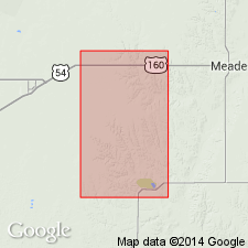
Pg. 9 (table 1), 23-24. Grand Island formation. Geographically extended into Wray area, in eastern Yuma County, eastern Colorado, and southwestern Dundy County, southwestern Nebraska. Does not crop out in natural exposures. Thickness about 10 feet, measured in gravel pits. Overlies Ogallala formation. Age is Pleistocene (Kansan).
Source: Publication; US geologic names lexicon (USGS Bull. 1200, p. 1566).
- Usage in publication:
-
- Grand Island member
- Modifications:
-
- Revised
- AAPG geologic province:
-
- Anadarko basin
Summary:
Pg. 55 (fig. 1). Chart of revised classification of Kansas Pleistocene shows Grand Island as member of unnamed formation in Meade group. [Age is Pleistocene (Kansan).]
Source: US geologic names lexicon (USGS Bull. 1200, p. 1566).
- Usage in publication:
-
- Grand Island formation
- Modifications:
-
- Overview
Summary:
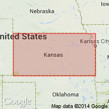
Shown as formation in Kansas.
Source: US geologic names lexicon (USGS Bull. 1200, p. 1566).
For more information, please contact Nancy Stamm, Geologic Names Committee Secretary.
Asterisk (*) indicates published by U.S. Geological Survey authors.
"No current usage" (†) implies that a name has been abandoned or has fallen into disuse. Former usage and, if known, replacement name given in parentheses ( ).
Slash (/) indicates name conflicts with nomenclatural guidelines (CSN, 1933; ACSN, 1961, 1970; NACSN, 1983, 2005, 2021). May be explained within brackets ([ ]).