

- Usage in publication:
-
- Grampian Hills member*
- Modifications:
-
- Named
- Dominant lithology:
-
- Clay
- Claystone
- Sand
- Sandstone
- AAPG geologic province:
-
- Mid-Gulf Coast basin
Summary:
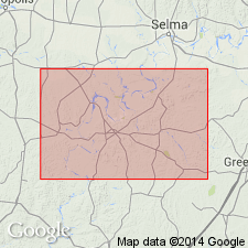
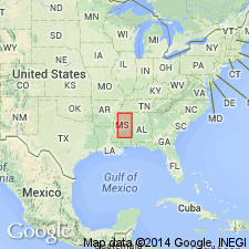
Grampian Hills member, first shown on correlation chart by Blanpied and Hazzard (1939: Shreveport Geological Society Guidebook, 14th Annual Field Trip, p. 128) is here adopted as upper member of the Nanafalia formation. Blanpied and Hazzard did not specify a type locality or section and so one is designated here along AL Hwy 41 on the south side of Gravel Creek valley, in Wilcox Co. At the type locality the entire thickness, including upper and lower contacts, is exposed. Unit consists of yellowish- to greenish-gray indurated clay or claystone. Includes several beds of greenish-gray coarse-grained glauconitic sand and sandstone and, in upper part, gray to greenish-gray massive blocky clay. Thickness is 80 to 110 ft in Grampian Hills area. Overlies unnamed middle member of formation; underlies Tuscahoma sand. [In Blanpied and Hazzard (1939), unit was shown to overlie Salt Mountain limestone member.]
Source: GNU records (USGS DDS-6; Reston GNULEX).
- Usage in publication:
-
- Grampian Hills Member*
- Modifications:
-
- Age modified
- AAPG geologic province:
-
- Mid-Gulf Coast basin
Summary:
Age of the Grampian Hills Member of the Nanafalia Formation of the Wilcox Group changed from early Eocene to Paleocene as the result of the change of the age of the Wilcox Group in the Gulf Coastal Plain. [Age change confirmed by oral communication with Joe Hazel, Chief, P & S, 1/6/76.]
Source: GNU records (USGS DDS-6; Reston GNULEX).

- Usage in publication:
-
- Grampian Hills Member
- Modifications:
-
- Overview
- AAPG geologic province:
-
- Mid-Gulf Coast basin
Summary:
Grampian Hills Member of Nanafalia Formation of Wilcox Group is AL State usage. The Grampian Hills is uppermost member and overlies a middle unnamed member, informally called the "OSTREA THIRSAE beds." This uppermost member consists of marine glauconitic sandy clay and dark-gray massive clay with glauconitic sand beds in places. Age is Paleocene.
Source: GNU records (USGS DDS-6; Reston GNULEX).
For more information, please contact Nancy Stamm, Geologic Names Committee Secretary.
Asterisk (*) indicates published by U.S. Geological Survey authors.
"No current usage" (†) implies that a name has been abandoned or has fallen into disuse. Former usage and, if known, replacement name given in parentheses ( ).
Slash (/) indicates name conflicts with nomenclatural guidelines (CSN, 1933; ACSN, 1961, 1970; NACSN, 1983, 2005, 2021). May be explained within brackets ([ ]).