

- Usage in publication:
-
- Government Canyon Granodiorite*
- Modifications:
-
- Named
- Dominant lithology:
-
- Granodiorite
- AAPG geologic province:
-
- Southwestern Basin-and-Range region
Summary:
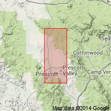
Named for exposures along Government Canyon, secs 2 and 11, T13N, R2W, Prescott quad, Yavapai Co, AZ, Southwestern Basin-and-Range province. No type locality designated. Was formerly mapped as a part of Bradshaw Granite, a term abandoned. Forms two masses. Disintegrates to a sandy soil, weathers brown. Fresh rock is medium-light-gray granodiorite. Ranges from massive to planar and linear structure. Is medium grained; parts are porphyritic. Is younger than unnamed volcanic rocks of the Alder? Group. Western mass cut by dikes of Prescott Granodiorite (new). Occurs as xenoliths in Prescott. Lead alpha age of zircon in Government Canyon is 930 m.y. Of Precambrian age. Geologic map.
Source: GNU records (USGS DDS-6; Denver GNULEX).
- Usage in publication:
-
- Government Canyon Granodiorite*
- Modifications:
-
- Geochronologic dating
- AAPG geologic province:
-
- Southwestern Basin-and-Range region
Summary:
Intrudes Green Gulch Volcanics of Big Bug Group (new) in Yavapai Co, AZ, Southwestern Basin-and-Range region. Yields an age of 1,770 +/-15 m.y. Is a late synkinematic or post-kinematic intrusive suggesting that the major part of the deformation of the Big Bug was completed prior to emplacement of Government Canyon. Geologic map.
Source: GNU records (USGS DDS-6; Denver GNULEX).

- Usage in publication:
-
- Government Canyon Granodiorite*
- Modifications:
-
- Age modified
- Overview
- AAPG geologic province:
-
- Southwestern Basin-and-Range region
Summary:
Assigned to suite two (of 4) in the Prescott area (Yavapai County, Arizona, Southwestern Basin-and-Range region). Suite two, consisting of pre- to syn-tectonic, equigranular, medium-grained hornblende-biotite tonalite and granodiorite plutons, includes the 1,740 +/-15 Ma tonalite of Cherry, 1,750 +/-15 Ma Government Canyon Granodiorite, and the Prescott Granodiorite. The plutons are metaluminous, have high magnetite concentrations, and high strontium, and are located both to the northwest and southeast of suite one. Government Canyon intruded by Prescott Granodiorite. Age is refined from Precambrian to Early Proterozoic. Report includes geochemical analyses.
Source: Modified from GNU records (USGS DDS-6; Denver GNULEX).
For more information, please contact Nancy Stamm, Geologic Names Committee Secretary.
Asterisk (*) indicates published by U.S. Geological Survey authors.
"No current usage" (†) implies that a name has been abandoned or has fallen into disuse. Former usage and, if known, replacement name given in parentheses ( ).
Slash (/) indicates name conflicts with nomenclatural guidelines (CSN, 1933; ACSN, 1961, 1970; NACSN, 1983, 2005, 2021). May be explained within brackets ([ ]).