The National Geologic Map Database is migrating to a new infrastructure. We apologize for any service disruptions during this process.
|
|---|


- Usage in publication:
-
- Gorgora shale member
- Modifications:
-
- Named
- Dominant lithology:
-
- Shale
- AAPG geologic province:
-
- Gulf Coast basin
Summary:
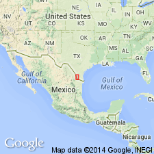
Named as member in middle part Fayette formation, Starr Co, TX (Gulf Coast basin). Type locality not designated. Occurs in conspicuous north-south valley across Starr and southern Zapata Cos, TX. "*** takes its name from Gorgora Hill, located 1 mi northeast of Roma, Roma Quadrangle, where base of member exposed in contact with Roma sandstone below." Electrical logs show thickness to increase northward from 500 ft in southern Starr Co to 900 ft in Zapata Co. Lower and upper parts are marine or lagoonal shales (marine or brackish-water) and thick middle part mostly nonmarine shale. Lower 30 ft gray shale; locally with Foraminifera, opalized TURRITELLA, other shells; also some lignite beds. Thick middle part blue, green, red bentonitic shales, thin sandstones, thin oyster beds; some thin sandstones associated with minor marine shales with Ostracoda, Foraminifera, fragments of larger shells; oyster beds and marine-lagoonal conditions more common to south; thin, tuffaceous, bench-making sandstones with fossil wood interbedded with red and green bentonitic shale. Upper 30 ft persistently marine or brackish-water deposit; shales green-gray, bentonitic, with Ostracoda, Foraminifera, oyster and other shell fragments; locally well developed oyster beds. Upper contact with Sanchez sandstone tongue well exposed 1 mi southwest of Agua Dulce Ranch. Assigned to Eocene. Cross section from Laredo to Rio Grande City (fig 2). Locality map.
Source: GNU records (USGS DDS-6; Denver GNULEX).
For more information, please contact Nancy Stamm, Geologic Names Committee Secretary.
Asterisk (*) indicates published by U.S. Geological Survey authors.
"No current usage" (†) implies that a name has been abandoned or has fallen into disuse. Former usage and, if known, replacement name given in parentheses ( ).
Slash (/) indicates name conflicts with nomenclatural guidelines (CSN, 1933; ACSN, 1961, 1970; NACSN, 1983, 2005, 2021). May be explained within brackets ([ ]).