The National Geologic Map Database is migrating to a new infrastructure. We apologize for any service disruptions during this process.
|
|---|


- Usage in publication:
-
- Gooseneck facies
- Modifications:
-
- Named
- Dominant lithology:
-
- Sandstone
- Siltstone
- Mudstone
- AAPG geologic province:
-
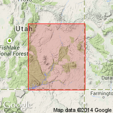
- Paradox basin
Summary:
Named as an informal unit in the Torrey Member of the Moenkopi Formation in the Paradox basin of southeast UT for Goosenecks Overlook on Sand Creek, Capitol Reef National Park on the Teasdale uplift. No type locality designated. Is characterized by several massive continuous, cross-stratified, ledge and cliff-forming sandstone with interbedded thinner sandstone, siltstone, and mudstone. The sheet-like sandstone bodies are 5 to 20 ft thick with low to very low angle cross stratification in lenticular trough sets several inches to 10 ft thick. Is present over much of Teasdale uplift, south-central San Rafael Swell, and southern Circle Cliffs. Believed to have been deposited in a delta front environment in Early Triassic time.
Source: GNU records (USGS DDS-6; Denver GNULEX).
For more information, please contact Nancy Stamm, Geologic Names Committee Secretary.
Asterisk (*) indicates published by U.S. Geological Survey authors.
"No current usage" (†) implies that a name has been abandoned or has fallen into disuse. Former usage and, if known, replacement name given in parentheses ( ).
Slash (/) indicates name conflicts with nomenclatural guidelines (CSN, 1933; ACSN, 1961, 1970; NACSN, 1983, 2005, 2021). May be explained within brackets ([ ]).