

- Usage in publication:
-
- Goon Dip Greenstone*
- Modifications:
-
- Named
- Dominant lithology:
-
- Greenstone
- Marble
- AAPG geologic province:
-
- Alaska Southeastern region
Summary:
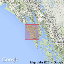
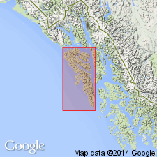
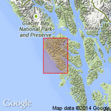
Type section: upper valley Goon Dip River east of Portlock Harbor, western Chichagof Island, southeast Alaska. Mainly sequence of greenstone, greenschist, and marble several thousand feet thick that crops out in a belt more than 30 miles long on western Chichagof Island. Lower contact obscured by plutonic igneous intrusives overlain in type locality by Whitestripe Marble; SE of Pinnacle Peak mostly overlain by Pinnacle Peak Phyllite. Equivalent to "greenstone" unit of Rossman (1959) in northwestern Chichagof Island. Largely equivalent to both "greenstone schist" and "greenstone" units mapped by Reed and Coats (1941) in Chichagof mining district who assigned a pre-Triassic(?) age to their "greenstone schist" and a Triassic(?) age to their "greenstone" unit, because of its assumed conformity with the overlying "limestone and marble" and "schist" units of Triassic(?) age. The pre-Triassic(?) is probably Permian, and a Permian(?) and Triassic(?) age is here used for the Goon Dip Greenstone. No fossils.
Source: GNU records (USGS DDS-6; Menlo GNULEX).
- Usage in publication:
-
- Goon Dip Greenstone*
- Modifications:
-
- Age modified
- Revised
- AAPG geologic province:
-
- Alaska Southeastern region
Summary:
Assigned as lowest unit of newly redefined Kelp Bay Group. Age changed from Permian(?) and Triassic(?) to Triassic(?) because Goon Dip Greenstone is predominantly volcanic and volcanic rocks are abundant in the Triassic but relatively rare in the Permian; therefore correlating Goon Dip with the Permian is unwarranted.
Source: GNU records (USGS DDS-6; Menlo GNULEX).
- Usage in publication:
-
- Goon Dip Greenstone*
- Modifications:
-
- Revised
- AAPG geologic province:
-
- Alaska Southeastern region
Summary:
Goon Dip Greenstone removed from the Kelp Bay Group; it is not present at type area of Kelp Bay Group and is recognized as part of Wrangellia terrane whereas group is part of Chugach terrane. Two terranes separated by Border Ranges fault. Correlated with Nikolai Greenstone by Plafker (1976) and Jones and others (1977). Triassic(?) age assignment retained.
Source: GNU records (USGS DDS-6; Menlo GNULEX).
For more information, please contact Nancy Stamm, Geologic Names Committee Secretary.
Asterisk (*) indicates published by U.S. Geological Survey authors.
"No current usage" (†) implies that a name has been abandoned or has fallen into disuse. Former usage and, if known, replacement name given in parentheses ( ).
Slash (/) indicates name conflicts with nomenclatural guidelines (CSN, 1933; ACSN, 1961, 1970; NACSN, 1983, 2005, 2021). May be explained within brackets ([ ]).