

- Usage in publication:
-
- Goodrich quartzite*
- Modifications:
-
- Named
- Dominant lithology:
-
- Quartzite
- Conglomerate
- AAPG geologic province:
-
- Lake Superior region
Summary:
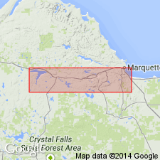
Is named as one of two divisions or formations in the Algonkian-age Ishpeming formation (new) at base of Upper Marquette series in the Marquette district (Lake Superior region). [Is unranked unit in context of present-day stratigraphic code, because formations cannot be divided into formations.] Is mapped (pl XIII) as part of Ishpeming formation. Is named for exposure at and adjacent to the Goodrich mine [location of mine is not given]. Overlies Negaunee formation (new) of Lower Marquette series; is overlain by Michigamme formation (new) of Upper Marquette series. Basal conglomerate of variable thickness grades upward into quartzite with minute fragments of chert and jasper; upper part is usually feldspathic. Is about 1550 ft thick.
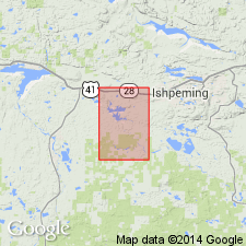
[Goodrich Mine in W/2 NW/4 sec. 19, T. 47 N. R. 27 W., (approx. Lat. 46 deg. 27 min. 33 sec. N., Long. 87 deg. 44 min. 18 sec. W.), Ishpeming 7.5-min quadrangle, Marquette Co., Northern Peninsula, northwestern MI.]
Source: GNU records (USGS DDS-6; Reston GNULEX).
- Usage in publication:
-
- Goodrich quartzite*
- Modifications:
-
- Overview
- AAPG geologic province:
-
- Lake Superior region
Summary:
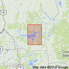
Is mapped only in south-central part of Kiernan quad, eastern Iron Co, MI (Lake Superior region). Map unit described as mostly dense, massive, red to dark-red-brown, fine- to medium-grained, ferruginous quartzite, predominantly clastic but commonly cherty; locally contains chert grains or platy fragments of an oolitic iron-formation, Negaunee?; strongly magnetic in most places; nonmagnetic phases generally deeply oxidized and contain much earthy iron oxide. Overlies Randville dolomite; underlies Hemlock formation. Thickness 0-500? ft. Outcrops found only on Michigamme Mountain and at two places in sec 4, T43N, R31W. Is placed northward from the mountain on basis of magnetic data; extended southward by magnetic data; extended eastward by magnetic and drilling data. Magnetic data suggests that the Goodrich is distributed in irregular pods rather than as a continuous layer; apparent irregular distribution could be result of original thickness variations, irregular development of magnetic phases of the quartzite, or erosion of the formation from most of area. Magnetic quartzite at Michigamme Mountain was formerly called Groveland formation by Clements and Smyth (1899) and Negaunee iron-formation by Van Hise and Leith (1911). Goodrich assigned to Middle Precambrian in this report.
Source: GNU records (USGS DDS-6; Reston GNULEX).
- Usage in publication:
-
- Goodrich quartzite*
- Modifications:
-
- Revised
- AAPG geologic province:
-
- Lake Superior region
Summary:
Pg. 30 (table 1), 36. Goodrich quartzite. Revised to basal formation of Baraga group (new) of Animikie series. Underlies Hemlock formation; overlies Vulcan iron-formation. Age is middle Precambrian (Animikie Series). Report includes stratigraphic sequence chart.
Source: US geologic names lexicon (USGS Bull. 1200, p. 1543).
- Usage in publication:
-
- Goodrich Quartzite*
- Modifications:
-
- Overview
- AAPG geologic province:
-
- Lake Superior region
Summary:
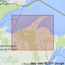
Pg. 2845 (fig. 2, stratigraphic chart compiled from Leith and others, 1935; James, 1958; Gair and Thaden, 1968). Goodrich Quartzite of Baraga Group of Marquette Range Supergroup (new; replaces †Animikie series of James, 1958, south of Lake Superior, in Michigan and Wisconsin). Present in Marquette Range, northwestern Michigan. Underlies Greenwood Iron-Formation Member of Michigamme Slate of Baraga Group. Overlies Negaunee Iron-Formation of Menominee Group with unconformity or disconformity in places. Age is middle Precambrian.
Source: Publication.
- Usage in publication:
-
- Goodrich Quartzite*
- Modifications:
-
- Overview
- AAPG geologic province:
-
- Lake Superior region
Summary:
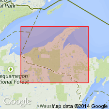
Is mapped as basal formation of Baraga Group in Marquette Range Supergroup, Marquette Co, MI (Lake Superior region). Poorly exposed unit. In general, is a thick, fining-upward sequence with a discontinuous basal conglomerate, overlain by coarse-grained quartzite that grades upward into argillite. Conglomerate: lenses a few feet to a few tens of feet thick; most clasts of pebble or larger size are derived entirely from iron-formation; most clasts angular; matrix mostly sand and granule size grains with some finer quartz, sericite, chlorite, and biotite; locally rich in magnetite and hematite. Quartzite: thick-bedded (6 in-1 ft) ortho- or protoquartzite; white, pink, and light-gray; typically 80-95 percent quartz sand in chloritic, biotitic, or sericitic matrix; rarely, rounded outlines of grains preserved as dust rims; grades upward into banded argillite, which is transitional to basal unit of Michigamme Formation. Precambrian X.
Source: GNU records (USGS DDS-6; Reston GNULEX).
For more information, please contact Nancy Stamm, Geologic Names Committee Secretary.
Asterisk (*) indicates published by U.S. Geological Survey authors.
"No current usage" (†) implies that a name has been abandoned or has fallen into disuse. Former usage and, if known, replacement name given in parentheses ( ).
Slash (/) indicates name conflicts with nomenclatural guidelines (CSN, 1933; ACSN, 1961, 1970; NACSN, 1983, 2005, 2021). May be explained within brackets ([ ]).