

- Usage in publication:
-
- Goodbread sandstone member
- Modifications:
-
- Original reference
- Dominant lithology:
-
- Sandstone
- AAPG geologic province:
-
- Gulf Coast basin
Summary:
Pg. 166-171. Goodbread sandstone member of Manning formation. Name applied to a sandstone in the Manning formation about 100 to 150 feet above the top of the Carlos sandstone. Thickness near type locality 5 to 30 feet; in Brazos County 40 to 50 feet. Separated from overlying Tuttle sandstone member (new) by a 75-foot interval that contains shales, shaly sandstone, lignitic beds, and ash beds. Unit had been mapped as part of Carlos sandstone by Renick (1936). Age is Eocene (Jackson).
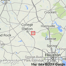
Type locality: on Lake Creek 1 mi west of Carlos, Grimes Co., east-central TX.
Source: US geologic names lexicon (USGS Bull. 1200, p. 1541).
For more information, please contact Nancy Stamm, Geologic Names Committee Secretary.
Asterisk (*) indicates published by U.S. Geological Survey authors.
"No current usage" (†) implies that a name has been abandoned or has fallen into disuse. Former usage and, if known, replacement name given in parentheses ( ).
Slash (/) indicates name conflicts with nomenclatural guidelines (CSN, 1933; ACSN, 1961, 1970; NACSN, 1983, 2005, 2021). May be explained within brackets ([ ]).