

- Usage in publication:
-
- Good Creek formation
- Modifications:
-
- Named
- Dominant lithology:
-
- Clay
- Silt
- Gravel
- AAPG geologic province:
-
- Palo Duro basin
Summary:
Pg. 568-582. Good Creek Formation. Name used for late Pleistocene deposits along Good Creek and Monument Creek. These deposits as well as those of Groesbeck Formation (Dalquest, 1965) were formerly considered part of middle Pleistocene Seymour Formation by Cummins (1893). Deposits are extensive [overall thickness of formation not stated by author]. In upper part of stream valleys, includes sluggish-stream, pond, and marsh sediments, mostly consisting of gray clays, bordered by yellowish sandy silts and yellowish sandy gravel. Cross-bedded sand, gravel, and conglomerate overlain by yellowish sandy gravel occupy central parts of valley. Good Creek Formation includes some deposits of reworked sand and gravel from the Seymour Formation. Is entrenched in Blaine Formation, as infilling of sinks on the upper Blaine surface. Age is late Pleistocene (Sangamon), based on fossils. An extensive vertebrate and freshwater invertebrate (mollusks) fauna is listed and the mammals are discussed in detail. Interglacial climate indicated, with summers similar to today but with warmer winters.
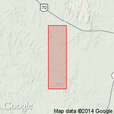
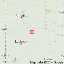
Type locality: fossil site on Easley Ranch in roadcut just west of bridge where State Farm Market Road 654 crosses Monument Creek in Foard Co., TX. Named from exposures along Good Creek and Monument Creek, Foard Co., Texas Panhandle, Palo Duro basin.
Source: US geologic names lexicon (USGS Bull. 1350, p. 297); supplemental information from GNU records (USGS DDS-6; Denver GNULEX).
- Usage in publication:
-
- Good Creek Formation
- Modifications:
-
- Revised
- AAPG geologic province:
-
- Permian basin
- Palo Duro basin
Summary:
Newly assigned as one of three named formations and some unnamed lacustrine and palustrine rocks to the Paducah Group (new) in the eastern and southern Rolling Plains of TX, Permian and Palo Duro basins. Is older than Groesbeck Formation of the Paducah Group and younger than the Seymour Formation of the Paducah Group of the eastern and southern Rolling Plains. Approximately equivalent to the lower part of the newly named Lingos Formation of the Paducah Group of the western and northern Rolling Plains. Of Rancholabrean, middle and late Pleistocene age. Stratigraphic chart.
Source: GNU records (USGS DDS-6; Denver GNULEX).
For more information, please contact Nancy Stamm, Geologic Names Committee Secretary.
Asterisk (*) indicates published by U.S. Geological Survey authors.
"No current usage" (†) implies that a name has been abandoned or has fallen into disuse. Former usage and, if known, replacement name given in parentheses ( ).
Slash (/) indicates name conflicts with nomenclatural guidelines (CSN, 1933; ACSN, 1961, 1970; NACSN, 1983, 2005, 2021). May be explained within brackets ([ ]).