The National Geologic Map Database is migrating to a new infrastructure. We apologize for any service disruptions during this process.
|
|---|


- Usage in publication:
-
- Golden Spike facies
- Modifications:
-
- Revised
- Dominant lithology:
-
- Conglomerate
- AAPG geologic province:
-
- Montana folded belt
Summary:
Golden Spike facies of Elkhorn Mountains volcanics. Is well exposed in walls of Clark Fork valley and in hills immediately south of river outside map area. In earlier reports, thought to be a conglomerate that probably correlated with Elkhorn Mountains volcanics. Is a 4,000 to 6,000-foot sequence of andesitic lava, andesitic tuff, limestone- and chert-pebble conglomerate, sandstone, and siltstone. Unconformably overlies Carter Creek formation (new) of Colorado group. Folding and faulting preceded deposition along eastern margin of Boulder batholith. Erosion prior to deposition was as deep as the Madison limestone. Has been correlated with Beaverhead conglomerate of southwest Montana. No fossils found that define age. Age is considered to be pre-Paleocene, or latest Cretaceous.
Source: US geologic names lexicon (USGS Bull. 1350, p. 295-296); supplemental information from GNU records (USGS DDS-6; Denver GNULEX).
- Usage in publication:
-
- Golden Spike formation
- Modifications:
-
- Original reference
- Dominant lithology:
-
- Conglomerate
- AAPG geologic province:
-
- Montana folded belt
Summary:
Pg. 2247 (Feb.). Named in report on Drummond area, Montana. Uplift and minor folding occurred in area during mid-Late Cretaceous time prior to deposition of unconformable Golden Spike formation and Elkhorn Mountains volcanics.
Source: US geologic names lexicon (USGS Bull. 1350, p. 295-296).
- Usage in publication:
-
- Golden Spike formation
- Modifications:
-
- Areal extent
- AAPG geologic province:
-
- Montana folded belt
Mutch, T.A., 1961, Geology of the northeast flank of the Flint Creek Range, western Montana: Dissertation Abstracts, v. 21, no. 8, p. 2250, scale 1:63,360, See also Montana Bur. Mines Geol., Geol. Map, no. 5 (Spec. Pub., no. 22), scale 1:63,360, and Princeton Univ. unpub. PhD dissert., 1960
Summary:
In Flint Creek Range, Cretaceous rocks consist of about 15,000 feet of clastic rocks. The youngest Cretaceous(?) sequence, Golden Spike formation, is characterized by presence of immature conglomerates and volcanic sandstones. Golden Spike is probable equivalent of Elkhorn volcanics, 70 miles to east. Probable angular unconformity between Kiss Creek [=Carter Creek of later reports?] and Golden Spike formations marks first pulse of local Laramide deformation.
Source: US geologic names lexicon (USGS Bull. 1350, p. 295-296).
- Usage in publication:
-
- Golden Spike facies
- Modifications:
-
- Revised
- AAPG geologic province:
-
- Montana folded belt
Summary:
Golden Spike facies described in Flint Creek Range where it consists of about 4,000 feet of conglomerate, sandstone, and siltstone, with some volcanic sandstone as well as extrusive volcanic rocks. Age not definitely known since no fossils have been found. Although no angular unconformity was observed between the Golden Spike and the Carter Creek formation, one is suggested by sharp lithologic break between the two units and by variable thickness of the Carter Creek.
Source: US geologic names lexicon (USGS Bull. 1350, p. 295-296).
- Usage in publication:
-
- Golden Spike Formation
- Golden Spike facies†
- Golden Spike member†
- Modifications:
-
- Principal reference
- Dominant lithology:
-
- Volcaniclastics
- Lava
- Conglomerate
- Sandstone
- AAPG geologic province:
-
- Montana folded belt
Summary:
Pg. 1125-1144. Formal proposal of name Golden Spike Formation. Treatment of Golden Spike strata as facies of Elkhorn Mountains Volcanics was attempted earlier but was not consistent with articles 6 and 7 of 1961 Code of Stratigraphic Nomenclature and was therefore abandoned. Thickness is 4,000 feet near Brock Creek and increases to the southeast to 8,000 feet near Rock Creek. Nonvolcanic rocks (e.g., conglomerates, sandstones, fine clastics) predominate in northwestern sixth of the 9-mile-long outcrop belt. In southeastern area, a relatively thick sequence comprises mostly lavas and volcaniclastic rocks (formed mainly by epigene processes rather than pyroclastic). Throughout formation many volcanic tongues wedge out within a short distance to northwest. At type section, herein designated, formation consists of (ascending): (1) basal conglomerate unit, 456 feet; (2) lower mixed unit with chaos beds 500 to 700 feet above base and nonvolcanic lenses in lower half, 2,088 feet; (3) middle lava unit, 907 feet; (4) middle mixed unit with prominent nonvolcanic zone near base, 1,911 feet; (5) upper lava unit, 536 feet; and (6) upper mixed unit, 946 feet. Base of formation is everywhere a topographically prominent zone of conglomerate and sandstone. Outcrop belt is terminated on northwest by northeast-trending high angle fault. Overlies Carter Creek Formation (not exposed); contact thought to be angular unconformity. Unconformably underlies Miocene sedimentary rocks and Quaternary gravel. Correlated with lower member of the Elkhorn Mountains Volcanics (Upper Cretaceous). Age is Late Cretaceous (post-Turonian), based on stratigraphic position.
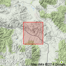
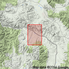
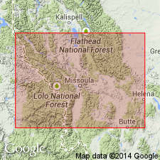
Type section: extends 2.5 mi west-southwestward from sides of northeast-projecting meander neck along Clark Fork River (in NE/4 SE/4 sec. 15, T. 9 N., R. 10 W.) to alluviated valley of Independence Creek (in NE/4 SE/4 sec. 20, T. 9 N., R. 10 W.), [Garrison 15-min quadrangle (1958), Powell Co., MT]. Name taken from locality in NE/4 NW/4 sec. 9, T. 9 N., R. 10 W., where sections of Northern Pacific RR and Pacific Northwest RR were joined; union was commemorated by driving of "golden spike" at point on southside of Clark Fork River. Occurs near town of Garrison, MT, 40 mi northwest of Butte at north end of Deer Lodge Valley, along a 9-mi-long northwest-trending belt.
Source: US geologic names lexicon (USGS Bull. 1350, p. 295-296); supplemental information from GNU records (USGS DDS-6; Denver GNULEX).
- Usage in publication:
-
- Golden Spike formation
- Modifications:
-
- Age modified
- AAPG geologic province:
-
- Montana folded belt
Summary:
Pg. 10, 12, 15. Golden Spike formation. In absence of definitive fossil evidence, age of Golden Spike and similar patches of conglomerate scattered about base of Flint Creek Range remains purely conjectural. Age is Tertiary(?).
Source: US geologic names lexicon (USGS Bull. 1350, p. 295-296).
- Usage in publication:
-
- Golden Spike Formation*
- Modifications:
-
- Age modified
- Overview
- AAPG geologic province:
-
- Montana folded belt
Summary:
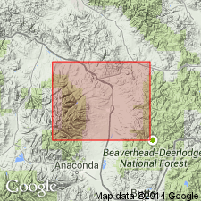
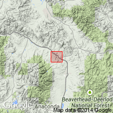
Occurs in area of Drummond, Granite County, Montana, and Anaconda, Deer Lodge County, Montana, south of Lewis and Clark line, a west- and northwest-trending fault zone in west-central Montana (Montana folded belt province). Underlain by Carten Creek Formation [=Carter Creek Formation of Montana Geol. Survey reports]. Overlying unit not discussed. Age of lower part inferred to be early Campanian based on correlation with lower part of Elkhorn Mountains Volcanics (citing Robinson and others, 1968, GSA Memoir 116, p. 566-568; they reported an isotopic age of about 80 Ma for upper part of the lower member of Elkhorn Mountains). Correlates with part of Two Medicine Formation of Wolf Creek area, on north side of Lewis and Clark line, in Lewis and Clark and Cascade Counties, Montana.
Source: Modified from GNU records (USGS DDS-6; Denver GNULEX).
For more information, please contact Nancy Stamm, Geologic Names Committee Secretary.
Asterisk (*) indicates published by U.S. Geological Survey authors.
"No current usage" (†) implies that a name has been abandoned or has fallen into disuse. Former usage and, if known, replacement name given in parentheses ( ).
Slash (/) indicates name conflicts with nomenclatural guidelines (CSN, 1933; ACSN, 1961, 1970; NACSN, 1983, 2005, 2021). May be explained within brackets ([ ]).