

- Usage in publication:
-
- Gold Flat Member*
- Modifications:
-
- Named
- Dominant lithology:
-
- Tuff
- AAPG geologic province:
-
- Great Basin province
Summary:
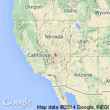
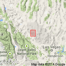
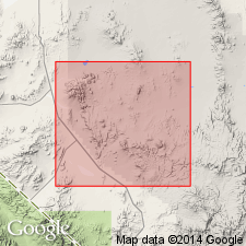
Named as a member (1 of 6) of Thirsty Canyon Tuff for exposures near Gold Flat in upper reach of Thirsty Canyon, Nye Co, NV in the Great Basin province. Its type locality is about 10 mi south of Gold Flat in the upper reach of Thirsty Canyon (lat 37 deg 15' N, long 116 deg 36' W). Is 170 ft thick at type. Consists of several inches to 8 ft of densely to partially fused light-brown tuff of air-fall origin. The basal tuff is succeeded by densely welded, generally devitrified, dark-green to gray tuff 20 ft thick, and upward by densely to moderately welded yellow-brown or brownish-red devitrified tuff [thickness not given]. Characterized by abundant lithic fragments and complexly twinned euhedral phenocrysts of alkali feldspar as much as 3 cm long, soda-rich sanidine crystals 1 to 5 mm diameter. Top of member near type is a distinctive flow with very abundant phenocrysts and by numerous cognate ejecta as much as several ft in diameter and composed dominantly of phenocrysts. Has a maximum thickness of about 200 ft. Overlies Dry Lake Member (new) of Thirsty Canyon. Underlies Labyrinth Canyon Member (new) of Thirsty Canyon. Distribution map. Pliocene age.
Source: GNU records (USGS DDS-6; Denver GNULEX).
- Usage in publication:
-
- Gold Flat Member*
- Modifications:
-
- Overview
- AAPG geologic province:
-
- Great Basin province
Summary:
Is one of few pantellerite ash-flow tuffs known, based on chemical and spectrographic analysis. Believed to have been generated by direct fractionation of liquids of alkali basalt, mugearite, or "mugearite-trachyte" composition without the intermediate phase of trachytic magma.
Source: GNU records (USGS DDS-6; Menlo GNULEX).
- Usage in publication:
-
- Gold Flat Member*
- Modifications:
-
- Age modified
- Geochronologic dating
- AAPG geologic province:
-
- Great Basin province
Summary:
See also Marvin and others, 1970, GSA Bull., v. 81, no. 9, p. 2657-2676. Gold Flat Member of Thirsty Canyon Tuff. Samples from nonhydrated glass-welded tuff vitrophyre in lowermost part of Gold Flat Member of Thirsty Canyon Tuff, on north flank of Black Mountain volcanic center, Lat. 37 deg. 20 min. 18 sec. N., Long. 116 deg. 39 min. 42 sec. W., Nye County, Nevada, yielded K-Ar ages of 7.8 +/-0.6 Ma and 9.5 +/-0.7 Ma (9.5 Ma age is apparently incorrect in comparison with ages of adjacent units in stratigraphic sequence). [Age is Miocene based on time scale of Berggren (1972, Lethaia, v. 5, no. 2, p. 195-215).]
Source: Modified from GNU records (USGS DDS-6; Menlo GNULEX).
- Usage in publication:
-
- Gold Flat Member*
- Modifications:
-
- Revised
- AAPG geologic province:
-
- Great Basin province
Summary:
Is one of five members of Thirsty Canyon Tuff derived from the Black Mountain volcanic center, Nye Co, NV in the Great Basin province. Thirsty Canyon divided into (ascending): Rocket Wash, Pahute Mesa (new), Trail Ridge, and Gold Flat Members, and the upper member. Stratigraphic table. Of late Miocene age.
Source: GNU records (USGS DDS-6; Denver GNULEX).
- Usage in publication:
-
- Gold Flat Tuff*
- Modifications:
-
- Revised
- AAPG geologic province:
-
- Great Basin province
Summary:
Within southwest Nevada volcanic field, Nye Co, NV, Great Basin province, units previously of formation rank are raised to group rank to allow for combining petrographically, geochemically, and temporally related lava flows and nonwelded tuffs with the principal correlative welded ash-flow tuff sheets (formerly members of the previous formation-rank tuffs). The ash-flow sheets are raised to formation rank and designated as "Tuff." Gold Flat is uppermost of four formations of Thirsty Canyon Group (rank raised). Older than Stonewall Flat Tuff; younger than Trail Ridge Tuff (rank raised) of Thirsty Canyon. [Thirsty Canyon also consists of several informal units not discussed in this paper.] Nomenclature shown on table 1. Miocene age.
Source: GNU records (USGS DDS-6; Denver GNULEX).
For more information, please contact Nancy Stamm, Geologic Names Committee Secretary.
Asterisk (*) indicates published by U.S. Geological Survey authors.
"No current usage" (†) implies that a name has been abandoned or has fallen into disuse. Former usage and, if known, replacement name given in parentheses ( ).
Slash (/) indicates name conflicts with nomenclatural guidelines (CSN, 1933; ACSN, 1961, 1970; NACSN, 1983, 2005, 2021). May be explained within brackets ([ ]).