

- Usage in publication:
-
- Godiva Rim Member*
- Modifications:
-
- Named
- Dominant lithology:
-
- Sandstone
- Mudstone
- Siltstone
- Oil-shale
- Limestone
- AAPG geologic province:
-
- Green River basin
Summary:
Named basal member of Green River Formation for Godiva Rim, Moffat Co, CO. Type section measured on slopes of Mount Baldy, NE1/4 sec 1, T8N, R96W, Moffat Co, Greater Green River basin where member 324 ft thick; overlies Cathedral Bluffs Tongue of Wasatch Formation; gradational into and underlies LaClede Bed of Laney Member of Green River; weathers gray; consists of tan to gray, very fine, fine- to coarse-grained, well to poorly sorted sandstone, soft gray-green, flaky to shaly to silty mudstone, tan soft argillaceous siltstone, gray-brown, flaky, soft silty shale, brown oil-shale, two tan silty limestone beds. Some beds current ripple marked; some trough cross-bedded. Ostracods, abundant worm trails, algal colonies. At type, lower contact is change from green mudstone (Cathedral Bluffs) to brown shale (Godiva Rim); upper contact is change from tan, very fine grained sandstone (Godiva Rim) to brown oil-shale (LaClede). Covered 2,600 sq mi on southeast margin Lake Gosiute. Areal extent map; west limit in R96W north-south across central Sand Wash and eastern Washakie basins. Ranges 160-375 ft thick. Of mixed shoreline, mudflat, and lacustrine origin. Early middle Eocene age assignment based on stratigraphic position between dated (fossil mammals) units in east part Washakie basin. Formerly mapped as gray zone of Wasatch in CO, as Laney in WY, as Cathedral Bluffs in WY and CO, as intertongued Laney and Cathedral Bluffs unit. Cross section.
Source: GNU records (USGS DDS-6; Denver GNULEX).

- Usage in publication:
-
- Godiva Rim Member*
- Modifications:
-
- Named
- Dominant lithology:
-
- Mudstone
- Oil-shale
- Sandstone
- Siltstone
- Shale
- Limestone
- AAPG geologic province:
-
- Green River basin
Summary:
Godiva Rim Member of the Green River Formation is named for exposures along the southeast slopes of Godiva Rim in the Sand Wash basin in T8N R96W, Moffat Co, CO. Type section lies on east slopes of Bald Mountain at northeast end of Godiva Rim in NE/4 sec.1, T8N R96W. Previously mapped as "gray zone" of Wasatch Formation in CO, Cathedral Bluffs Tongue of Wasatch in WY, basal part of Laney Member of the Green River Formation, and the unnamed basal tongue of the Laney. Type section consists of gray-brown kerogenaceous shale and brown oil shale, tan or gray, partly ostracode-bearing parallel-bedded siltstone and sandstone, tan ostracodal limestone and sandstone, gray or green mudstone, gray, fine to very coarse-grained, trough cross-bedded sandstone, and tan limestone. Is 324 ft thick at type (range 160 to 375 ft). Conformably overlies (at type) Cathedral Bluffs; conformably underlies LaClede Bed of Laney. Age is early middle Eocene on the basis of stratigraphic position between units containing age-diagnostic vertebrate fossils.
Source: GNU records (USGS DDS-6; Menlo GNULEX).
- Usage in publication:
-
- Godiva Rim Member*
- Modifications:
-
- Areal extent
- Overview
- AAPG geologic province:
-
- Green River basin
Summary:
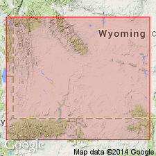
Isopach map (fig 28) shows areal extent within Greater Green River basin, WY and CO. Godiva Rim (Green River Formation) is restricted to parts of Great Divide, Washakie, and Sand Wash basins. Intertongues with and is gradually replaced by upper part of Cathedral Bluffs Tongue of Wasatch Formation northward in outcrops across central part of Sand Wash basin and along east margins of Washakie basin. Intertongues with and is laterally replaced by LaClede Bed of Laney Member of Green River in subsurface in Sand Wash and Washakie basins. Maximum thickness is 350 ft in southern part of Sand Wash basin; thins to 125 ft in northern part of Washakie basin. Stratigraphic chart; cross sections. Eocene age.
Source: GNU records (USGS DDS-6; Denver GNULEX).
For more information, please contact Nancy Stamm, Geologic Names Committee Secretary.
Asterisk (*) indicates published by U.S. Geological Survey authors.
"No current usage" (†) implies that a name has been abandoned or has fallen into disuse. Former usage and, if known, replacement name given in parentheses ( ).
Slash (/) indicates name conflicts with nomenclatural guidelines (CSN, 1933; ACSN, 1961, 1970; NACSN, 1983, 2005, 2021). May be explained within brackets ([ ]).