

- Usage in publication:
-
- Goat Hill Member*
- Modifications:
-
- Named
- Dominant lithology:
-
- Greenstone
- Breccia
- AAPG geologic province:
-
- Sierra Nevada province
Summary:
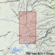
Named for Goat Hill. Type sec: exposures on N bank of Mokelumne River, sec 16-17 T5N R11E about 1 km S of Goat Hill, Amador Co, CA. Included as member of Logtown Ridge Formation. At Mokelumne River was called units 30-32 of Brower Creek Volcanic Member of Mariposa Fm (Clark, 1964, pl.8). Consists of greenstone interbedded with volcanic breccia and tuff with minor slate; cut-and-fill structures, soft-sediment deformation, fossiliferous. Conformably overlies Rabbit Flat Member (new); conformably underlies Pokerville Member (new) southward to Jackass Gulch area, beyond which it becomes uppermost member. Age is Late Jurassic (Callovian) based on ammonites. [Callovian is Late Jurassic in this paper].
Source: GNU records (USGS DDS-6; Menlo GNULEX).
- Usage in publication:
-
- Goat Hill Member*
- Modifications:
-
- Age modified
- AAPG geologic province:
-
- Sierra Nevada province
Summary:
Age changed based on Middle-Upper Jurassic boundary change based on top of Callovian-bottom of Oxfordian. Thus Goat Hill Member (Callovian) is Middle Jurassic.
Source: GNU records (USGS DDS-6; Menlo GNULEX).
For more information, please contact Nancy Stamm, Geologic Names Committee Secretary.
Asterisk (*) indicates published by U.S. Geological Survey authors.
"No current usage" (†) implies that a name has been abandoned or has fallen into disuse. Former usage and, if known, replacement name given in parentheses ( ).
Slash (/) indicates name conflicts with nomenclatural guidelines (CSN, 1933; ACSN, 1961, 1970; NACSN, 1983, 2005, 2021). May be explained within brackets ([ ]).