

- Usage in publication:
-
- Glendon limestone member*
- Modifications:
-
- Named
- Dominant lithology:
-
- Limestone
- AAPG geologic province:
-
- Mid-Gulf Coast basin
Summary:
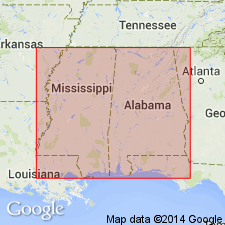
Glendon limestone member at the top of the Marianna limestone (new name) crops out as a series of ledges of hard, partly crystalline yellowish or pinkish limestone interbedded with softer strata of impure limestone composed largely of Bryozoa, Foraminifera, and shells of OSTREA VICKSBURGENSIS and PECTEN POULSONI. It is distinguished from other parts of the Marianna mainly by its lithology, but also by a few species of organisms that are not found elsewhere. At Glendon, AL, it is 18 or 20 ft thick and overlies 20 ft of "chimney rock" [a facies of the Marianna]. In MS, it rests on the Mint Spring calcareous marl member of the Marianna limestone. Underlies the Byram calcareous marl. Because of its hardness, it is the most conspicuous part of the Vicksburg group in MS. Age is Oligocene.
Source: GNU records (USGS DDS-6; Reston GNULEX).
- Usage in publication:
-
- Glendon limestone*, formation*
- Modifications:
-
- Revised
- AAPG geologic province:
-
- Mid-Gulf Coast basin
- South GA-North FL sedimentary province
Summary:
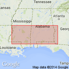
Glendon limestone member is elevated in rank to Glendon limestone. Unit is extended into GA where lithology changes to sands, clays, and cherts and it is known as the Glendon Formation. Strata had been mapped previously as part of the Chattahoochee or Ocala. [Cooke later decided the beds in GA and FL were actually younger than true Glendon and he renamed them Flint River formation.]
Source: GNU records (USGS DDS-6; Reston GNULEX).
- Usage in publication:
-
- Glendon limestone member*
- Modifications:
-
- Revised
- AAPG geologic province:
-
- Mid-Gulf Coast basin
Summary:
Glendon reduced in rank to member status in the Byram formation. Underlies unnamed marl member and overlies sandy facies of Marianna limestone. At type section, lower 12 ft consists of coarsely porous, crumbly to hard, crystalline, orbitoidal limestone with well developed but unevenly cemented ledges and interbedded less resistant zones. Hard ledges characteristically weather to "horsebone," and locally entire interval is more evenly indurated and so weathered. Above the coarse limestone, and constituting the remainder of type section, are a least three hard smooth yellowish-brown limestone ledges interbedded with soft fossiliferous argillaceous marl. Evidence indicates that the hard crystalline limestone and open-spaced coquinas of type section pass westward into thicker, more uniform section of buff to cream, hard to soft argillaceous marlstone and tough limestone. Sharper faunal break exists between Marianna and Glendon in AL than around Vicksburg. Eastward from type locality, member becomes more uniformly indurated and difficult to differentiate from the Marianna. In vicinity of Marianna, FL, unit is largely altered to dolomite. Thickness at Marianna is about 18 ft.
Source: GNU records (USGS DDS-6; Reston GNULEX).
- Usage in publication:
-
- Glendon Limestone Member*
- Modifications:
-
- Age modified
- AAPG geologic province:
-
- Mid-Gulf Coast basin
Summary:
Age of the Vicksburg Group changed from middle to early Oligocene. Age change of the units within the Vicksburg is inferred.
Source: GNU records (USGS DDS-6; Reston GNULEX).
- Usage in publication:
-
- Glendon Formation*
- Modifications:
-
- Revised
- AAPG geologic province:
-
- Mid-Gulf Coast basin
Summary:
Glendon raised in rank from Glendon Limestone Member of Byram Formation to Glendon Formation of Vicksburg Group. Overlies Marianna Formation and underlies Byram Formation, both of Vicksburg.
Source: GNU records (USGS DDS-6; Reston GNULEX).

- Usage in publication:
-
- Glendon Limestone, Limestone Member
- Modifications:
-
- Overview
- AAPG geologic province:
-
- Mid-Gulf Coast basin
Summary:
Glendon Limestone Member of Byram Formation is AL State usage. Glendon Limestone of Vicksburg Group is MS State usage. The Glendon or equivalent units have been recognized from the FL panhandle to the vicinity of Vicksburg, Warren Co., MS. Throughout MS and AL, the Glendon can be recognized by its distinctive alternating beds of indurated and non-indurated rocks and its relatively uniform thickness. Generally, the indurated beds consist of cemented fossiliferous packstone and grainstone and the softer beds of mudstone, wackestone, and argillaceous marl.
Source: GNU records (USGS DDS-6; Reston GNULEX).
- Usage in publication:
-
- Glendon Limestone
- Modifications:
-
- Areal extent
- Overview
- AAPG geologic province:
-
- South Georgia sedimentary province
Summary:
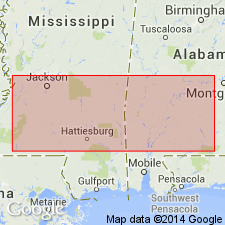
Use of term Vicksburg Group extended to GA to encompass outliers of Marianna Limestone and Glendon Limestone. In GA, the only known occurrence of the Glendon is in a bluff on the Ocmulgee River near Hawkinsville in Pulaski Co. The name Glendon was once applied extensively to limestones and residuum in southwestern GA, but Cooke (1935) abandoned the name Glendon in GA and assigned the deposits to the Flint River formation. They are here reassigned to the Bridgeboro Limestone (new). The Glendon on the Ocmulgee River consists of alternating hard and soft layers of limestone. Limestone in the ledges is partially recrystallized and consists mostly of calcium carbonate, while the limestone in the reentrants is argillaceous, silty, and consists of only about 70 percent of calcium carbonate. The GA Glendon differs from the typical Glendon in being very sparsely macrofossiliferous and does not contain any significant number of LEPIDOCYCLINA, the characteristic fossil of the AL Glendon. The soft limestone, however, is abundantly microfossiliferous. Though the occurrence of the Glendon may once have been continuous from central GA to the Mississippi River, it is only spotty now. Unit is roughly 10 ft thick on the Ocmulgee River where it conformably overlies the Marianna Limestone. Underlies surficial sand in outcrop. Age is early Oligocene (Rupelian).
Source: GNU records (USGS DDS-6; Reston GNULEX).
For more information, please contact Nancy Stamm, Geologic Names Committee Secretary.
Asterisk (*) indicates published by U.S. Geological Survey authors.
"No current usage" (†) implies that a name has been abandoned or has fallen into disuse. Former usage and, if known, replacement name given in parentheses ( ).
Slash (/) indicates name conflicts with nomenclatural guidelines (CSN, 1933; ACSN, 1961, 1970; NACSN, 1983, 2005, 2021). May be explained within brackets ([ ]).