

- Usage in publication:
-
- Gilliam formation
- Modifications:
-
- Original reference
- Dominant lithology:
-
- Limestone
- Dolomite
- Sandstone
- AAPG geologic province:
-
- Permian basin
Summary:
Pg. 52. Gilliam formation. Present in southern Trans-Pecos region, Glass Mountains, Brewster County, West Texas. Gray, light-colored, reddish limestone and dolomite, nearly massive, or at least bedding planes are very dim. In middle the limestone shows thick lenticular beds. In lower part it is decidedly thin-bedded. At base we find thicker layers of reddish dolomite alternating with thinly laminated layers of same rock and with thin strata of yellowish marly sandstone. Thickness 2,600 feet in Gilliam Canyon, Glass Mountains. Is top formation of Permian of Marathon region. Overlies Vidrio formation; underlies Tessey formation. Probably correlates with Castile gypsum and Rustler limestone. Age is Permian. Report includes geologic map.
Source: US geologic names lexicon (USGS Bull. 896, p. 819-820); supplemental information from GNU records (USGS DDS-6; Denver GNULEX).
- Usage in publication:
-
- Gilliam formation
- Modifications:
-
- Revised
- AAPG geologic province:
-
- Permian basin
Summary:
Pg. 52-53. Gilliam formation. Yellow dolomitic limestone, in places pinkish and even brownish in color; stratification planes sharply marked and straight, and especially in lower part the rock is quite thin-bedded. To the southwest of White Elephant tank there is in this formation a well-sorted, brown sandstone of average texture, 20 feet thick. This sandstone was also observed in Gilliam Canyon and seems to be persistent. Thickness 743 feet. Grades into overlying Tessey formation (1,400 feet thick), which is topmost Permian formation, and typically exposed 2+/- miles north of Gilliam Canyon. Conformably overlies Vidrio formation. Traces of forams (e.g., TROCHAMMINA and AMMODISCUS) identified in thin sections, but so far no recognizable large fossils have been found. Age is Permo-Carboniferous. Report includes geologic map. [This appears to be a redefinition of Gilliam formation.]
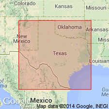
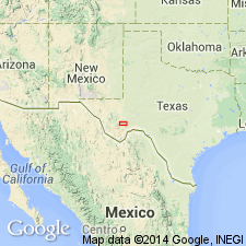
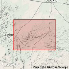
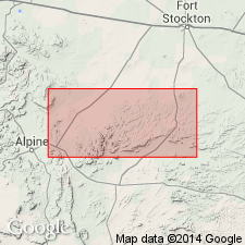
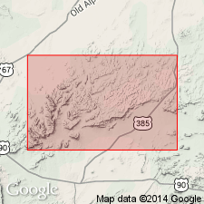
Named from Gilliam Canyon [Gilliand Canyon], Glass Mountains, Brewster Co., TX (Permian basin), where exposed in bluffs of its narrowest part, beginning about 10 mi north of south end of Iron Mountain, and continuing for nearly 2 mi northward.
[Gilliland Canyon in vicinity of Lat. 30 deg. 27 min. 48 sec. N., Long. 103 deg. 14 min. 28 sec. W., Hess Canyon 7.5-min quadrangle, Brewster Co., western TX.]
Source: Publication; US geologic names lexicon (USGS Bull. 896, p. 819-820); supplemental information from GNU records (USGS DDS-6; Denver GNULEX).
- Usage in publication:
-
- Gilliam formation
- Modifications:
-
- Overview
- AAPG geologic province:
-
- Permian basin
Summary:
Pg. 136-140, pl. 1. Gilliam formation. Was named for a canyon that was supposed to be spelled Gilliam, but Hess Canyon and Altuda topgraphic sheets spell the canyon Gilliand, and that is spelling adopted by the U.S. Geographic Board. The committee of geologic names of the USGS, however, regards it as inadvisable to change the spelling of the formation, which is well-established as Gilliam formation.
Section measured in Hess Canyon, Glass Mountains, Brewster County, Texas, includes (ascending) Vidrio formation, 900 feet; Gilliam formation, 900 feet; and Tessey formation, 1,000 feet. In region a few miles to the southwest, on flanks of Sierra Madera, not possible to subdivide the group, and the 3 formations are mapped together. About 2 miles west of Gilliland Canyon the Gilliam changes over abruptly into massive dolomites and is not traceable toward the west. At about the same point where Gilliam loses its identity, another thin-bedded series appears at a lower level (= Altuda member of Vidrio). Vidrio, Gilliam, and Tessey are equivalent of Capitan limestone. Age is Permian. Report includes geologic map.
[Gilliland Canyon in vicinity of Lat. 30 deg. 27 min. 48 sec. N., Long. 103 deg. 14 min. 28 sec. W., Hess Canyon 7.5-min quadrangle, Brewster Co., TX.]
Source: Publication; US geologic names lexicon (USGS Bull. 896, p. 819-820); supplemental information from GNU records (USGS DDS-6; Denver GNULEX).
- Usage in publication:
-
- Gilliam member*
- Modifications:
-
- Revised
- AAPG geologic province:
-
- Permian basin
Summary:
Pg. 73-84. Gilliam member of Capitan formation. [see 1930 (1931) entry under Capitan.]
Source: US geologic names lexicon (USGS Bull. 896, p. 820).
- Usage in publication:
-
- Gilliam thin-bedded member
- Modifications:
-
- Revised
- AAPG geologic province:
-
- Permian basin
Moore, R.C., 1933, Historical geology: McGraw-Hill Book Co., 673 p.
Summary:
Pg. 325 (P.B. King credited). Gilliam thin-bedded member of Glass Mountains formation. [See 1933 entry under Capitan.]
Source: US geologic names lexicon (USGS Bull. 896, p. 820).

- Usage in publication:
-
- Gilliam thin-bedded member*
- Modifications:
-
- Overview
- AAPG geologic province:
-
- Permian basin
Summary:
The present approved name of the USGS is Gilliam thin-bedded member of Capitan limestone. †Glass Mountains formation abandoned. This name being preoccupied, and the rocks being the southern extension of Capitan limestone (an older and well-established name), the USGS designates these rocks in Glass Mountains the Capitan limestone. (See P.B. King, 1934, GSA Bull., v. 45, p. 697-798).
Source: US geologic names lexicon (USGS Bull. 896, p. 820, 825, entries under Gilliam and Glass Mountains).
For more information, please contact Nancy Stamm, Geologic Names Committee Secretary.
Asterisk (*) indicates published by U.S. Geological Survey authors.
"No current usage" (†) implies that a name has been abandoned or has fallen into disuse. Former usage and, if known, replacement name given in parentheses ( ).
Slash (/) indicates name conflicts with nomenclatural guidelines (CSN, 1933; ACSN, 1961, 1970; NACSN, 1983, 2005, 2021). May be explained within brackets ([ ]).