The National Geologic Map Database is migrating to a new infrastructure. We apologize for any service disruptions during this process.
|
|---|


- Usage in publication:
-
- Geyser Creek Fanglomerate*
- Modifications:
-
- Named
- Dominant lithology:
-
- Conglomerate
- Sandstone
- AAPG geologic province:
-
- Paradox basin
Summary:
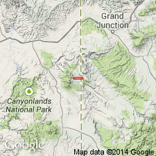
Named for Geyser Creek, San Juan Co, UT. Type section designated and measured on north side of Deep Creek in NE1/4 sec 36, T26S, R25E, Grand Co, UT. Crops out in Taylor Creek syncline on open northwestward-trending fold about 5 mi long and 2 mi wide located on the southeast flank of the North Mountain group of the La Sal Mountains. The syncline marks the northeast side of Paradox valley. Measured sections. Geologic map. Forms a distinctive yellow-brown cliff above slopes of Mancos Shale and below terrace gravels of Harpole Mesa Formations. Both contacts are angular unconformities. Is 117.5 ft thick at type. Ranges from 0 to as much as 1,000 ft thick. Wedges out on west along Deep and Geyser Creeks. Consists of well-consolidated, yellowish-brown conglomerate and sandstone in lenticular beds. The conglomerate has angular to subround pebbles and boulders mostly of quartz and diorite, some boulders and pebbles: of sandstone can be identified as to source (Kayenta, Chinle, Summerville, Salt Wash Sandstone Member, Burro Canyon Formation); of siltstone from Brushy Basin Shale Member, Burro Canyon Formation; of limestone from Mancos Shale. Sandstone is brown, gray, orange, pink, mainly (80-90%) quartz and very fine to coarse grained, poorly sorted, and well indurated. Tentatively assigned to Pliocene. Is younger than La Sal Mountains intrusion (source of diorite pebbles).
Source: GNU records (USGS DDS-6; Denver GNULEX).
For more information, please contact Nancy Stamm, Geologic Names Committee Secretary.
Asterisk (*) indicates published by U.S. Geological Survey authors.
"No current usage" (†) implies that a name has been abandoned or has fallen into disuse. Former usage and, if known, replacement name given in parentheses ( ).
Slash (/) indicates name conflicts with nomenclatural guidelines (CSN, 1933; ACSN, 1961, 1970; NACSN, 1983, 2005, 2021). May be explained within brackets ([ ]).