The National Geologic Map Database is migrating to a new infrastructure. We apologize for any service disruptions during this process.
|
|---|


- Usage in publication:
-
- Gerrit Basalt*
- Modifications:
-
- Named
- Geochronologic dating
- Dominant lithology:
-
- Basalt
- AAPG geologic province:
-
- Snake River basin
Summary:
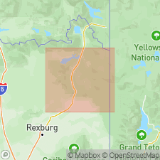
Named from RR siding 5 km east of Upper Mesa Falls; type area designated as canyon of Henrys Fork of Snake River, upstream for about 5 km from Upper Mesa Falls, in Island Park area, Fremont Co, ID, Snake River basin. Type area basalt overlies an erosional surface cut on Lava Creek and Mesa Falls Tuffs (both of Yellowstone Group) both concordantly and discordantly. This basalt--which erupted from several separate small volcanoes in Island Park--forms canyon rim on north and east sides of the river and also overlies a lower-level terrace cut on Mesa Falls Tuff. Overlain in type area only by upper Pleistocene loess and local sand and silt. In only one place does a dated volcanic unit probably overlie Gerrit; Gerrit and the 150,000-year-old Buffalo Lake flow--a third-cycle postcaldera rhyolite [of Central Plateau Member of Plateau Rhyolite] that overflowed Yellowstone caldera--are adjacent about 4.5 km east of Ripley Butte in northern Island Park. Here a small vent for the basalt fed flows that extended short distances in all directions but appear not to have ponded at the rhyolite flow front; also, there are no inclusions of Buffalo Lake in the basalt near the brecciated rhyolitic flow front. Hence, basalt is probably older. More evidence: a generally thicker and more continuous mantle of loess is on Gerrit than on adjacent flows of Plateau Rhyolite. One of the youngest Gerrit flows yields a K-Ar age of 200,000 yrs (Obradovich, written commun., 1982).
Source: GNU records (USGS DDS-6; Denver GNULEX).
For more information, please contact Nancy Stamm, Geologic Names Committee Secretary.
Asterisk (*) indicates published by U.S. Geological Survey authors.
"No current usage" (†) implies that a name has been abandoned or has fallen into disuse. Former usage and, if known, replacement name given in parentheses ( ).
Slash (/) indicates name conflicts with nomenclatural guidelines (CSN, 1933; ACSN, 1961, 1970; NACSN, 1983, 2005, 2021). May be explained within brackets ([ ]).