The National Geologic Map Database is migrating to a new infrastructure. We apologize for any service disruptions during this process.
|
|---|


- Usage in publication:
-
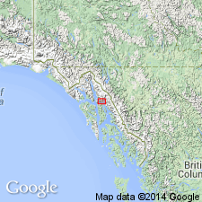
- Gastineau Channel Formation*
- Modifications:
-
- Named
- Dominant lithology:
-
- Till
- Gravel
- Sand
- AAPG geologic province:
-
- Alaska Southeastern region
Summary:
Named after Gastineau Channel, fiord that separates Juneau mainland from Douglas Island. Type area designated as low-lying land along Gastineau Channel on Juneau mainland and Douglas Island and along Montana Creek valley, southeastern AK. Three facies consist of (1) oldest, stone-rich diamicton that is till-like mixture of clasts within silt and sand matrix, (2) gravel-rich diamicton that is hard and dense, and (3) sand-rich diamicton, finest-grained and least dense of 3. Contains marine mollusks, barnacles, and foraminifers. Radiocarbon determinations on shells indicate late Pleistocene and early Holocene age.
Source: GNU records (USGS DDS-6; Menlo GNULEX).
For more information, please contact Nancy Stamm, Geologic Names Committee Secretary.
Asterisk (*) indicates published by U.S. Geological Survey authors.
"No current usage" (†) implies that a name has been abandoned or has fallen into disuse. Former usage and, if known, replacement name given in parentheses ( ).
Slash (/) indicates name conflicts with nomenclatural guidelines (CSN, 1933; ACSN, 1961, 1970; NACSN, 1983, 2005, 2021). May be explained within brackets ([ ]).