

- Usage in publication:
-
- Garden City limestone*
- Modifications:
-
- Original reference
- Biostratigraphic dating
- Dominant lithology:
-
- Limestone
- AAPG geologic province:
-
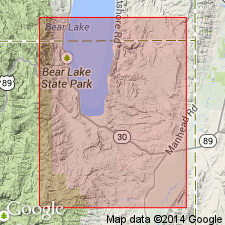
- Wasatch uplift
Summary:
Pg. 407, 408-409. Garden City limestone. Thick- and thin-bedded gray limestone, 1,000 feet thick. Conformably underlies Swan Peak quartzite and overlies St. Charles limestone with evidence of erosional unconformity. Contains Beekmantown fauna. [Fossils listed on p. 408-409; identified by Edwin Kirk, USGS.] Age is Early Ordovician.
Named from exposures in Garden City Canyon, Rich Co., northeastern UT.
Source: US geologic names lexicon (USGS Bull. 896, p. 799).
- Usage in publication:
-
- Garden City limestone*
- Modifications:
-
- Areal extent
- Biostratigraphic dating
- AAPG geologic province:
-
- Wasatch uplift
Summary:
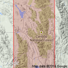
Geographically extended into southeast ID north of its type locality. Mapped (geologic map) at west side of Montpelier quad in Bear Lake Co, ID on the Wasatch uplift. Consists of about 1,250 ft of thick- and thin-bedded, gray limestone. Conglomerate or breccia of elongated limestone fragments (up to 2 or 3 inches long) embedded in a matrix of similar composition present throughout formation. Produces large sinks. Extensive fauna (listed) of Beekmantown age. Overlies St. Charles limestone. Underlies Swan Peak quartzite. Assigned to the Early Ordovician. Stratigraphic charts.
Source: GNU records (USGS DDS-6; Denver GNULEX).
- Usage in publication:
-
- Garden City formation*
- Modifications:
-
- Areal extent
- Revised
- Age modified
- AAPG geologic province:
-
- Great Basin province
Summary:
Geographically extended south from northern UT to exposures at south end of Thomas Range, near Spor Mountain, and in west and central parts of Dugway Range, Tooele Co, UT in the Great Basin province. Section 1,724 ft thick measured one-half mi south of head of Straight Canyon, east-central Dugway Range where formation overlies Dugway Ridge dolomite (new) and underlies Swan Peak formation. Base placed at top of highest dolomite of Dugway Ridge. Top placed at base of brown calcareous shale and interbedded red limestone of Swan Peak. Is a distinctive gray, fine-grained limestone that weathers light shades of purple, green, and pink. [Designated as "formation" though is not redescribed.] Upper part is also nodular and characterized by abundant fossils. Is dolomitized on west side of Dugway Range. Fossil list includes trilobites, ostracodes, brachiopods, mollusks, Porifera, graptolites. Age changed from Early Ordovician to Early and Middle Ordovician; Middle Ordovician boundary is in upper part. In Dugway Range Early-Middle Ordovician boundary is within interval between 180-340 ft below top of formation; greatest part of unit is Early Ordovician age. Correlates with Pogonip group. Geologic map. Stratigraphic sections. Measured sections.
Source: GNU records (USGS DDS-6; Denver GNULEX).
- Usage in publication:
-
- Garden City Formation*
- Modifications:
-
- Areal extent
- Overview
- AAPG geologic province:
-
- Snake River basin
Summary:
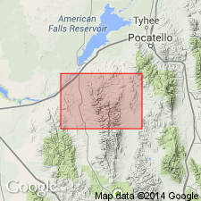
Mapped in northeast part of study area and extended into Snake River basin, Power Co, southeast ID. No continuous section is present; most nearly complete section is east of Crystal Creek where top of unit is present but base is faulted out. Lower part is well exposed, though faulted, on southwest flank of hill between Starlight and Moonshine Creeks. Consists mainly of blue-gray fine- to medium-grained slabby limestone which is dolomitized locally; lower 500 ft contains much intraformational conglomerate, and some bioclastic layers; layered black chert present in upper 100 ft in Crystal Creek area. Conformably overlies St. Charles Formation; conformably underlies Swan Peak Quartzite. In Arbon quad thickness is estimated to be 1200 ft or less. Trilobite faunal assemblage from lower 200-300 ft is typical of zone B of Garden City (Ross, 1951, Yale Univ. Peabody Mus. Nat. History Bull. 6). Assigned an Early Ordovician age.
Source: GNU records (USGS DDS-6; Denver GNULEX).
- Usage in publication:
-
- Garden City Limestone*
- Modifications:
-
- Areal extent
- AAPG geologic province:
-
- Snake River basin
Summary:
Garden City Limestone is extended into Bannock County, Idaho, Snake River basin. Mapped in northwest, central, and south-central parts of Hawkins quadrangle; outcrops have small areal extent. Consists of dark-gray limestone and minor dolomite; contains many intraformational pink to light-gray weathering conglomerate beds; chert nodules abundant near top. Thickness about 300 m. Conformably overlies St. Charles Limestone; conformably underlies Swan Peak Quartzite. Age is Early and Middle Ordovician; [basis of age assignment not stated].
[Remark on age assignments (modified from GNU records, USGS DDS-6, Denver GNULEX, ca. 1992): in this report, and in Oriel and Platt (1980, Preston quadrangle, USGS I-map 1127) and Oriel and others (1991, Elkhorn Peak quadrangle, USGS MF-map 2162), the Garden City is assigned an Early and Middle Ordovician age; presumably following the work of Staatz and Carr (1964) in the Dugway Range, northern Utah. However, in Trimble (1982, Yandell Springs quadrangle, USGS GQ-map 1553), Kellogg and others (1989, Jeff Cabin Creek quadrangle, USGS GQ-map 1669), Kellogg (1990, South Putnam Mountain quadrangle, USGS GQ-map 1665), and Hladky and others (1992, eastern part of Fort Hall Indian Reservation, USGS I-map 2006), the Garden City is assigned an Early Ordovician age; presumably following the work of Trimble and Carr (1976) in the Rockland and Arbon quadrangles (which border west boundary of Hawkins quadrangle), where they assigned an Early Ordovician age to the Garden City based on trilobites.]
Source: Modified from GNU records (USGS DDS-6; Denver GNULEX).
For more information, please contact Nancy Stamm, Geologic Names Committee Secretary.
Asterisk (*) indicates published by U.S. Geological Survey authors.
"No current usage" (†) implies that a name has been abandoned or has fallen into disuse. Former usage and, if known, replacement name given in parentheses ( ).
Slash (/) indicates name conflicts with nomenclatural guidelines (CSN, 1933; ACSN, 1961, 1970; NACSN, 1983, 2005, 2021). May be explained within brackets ([ ]).