

- Usage in publication:
-
- Galum limestone member
- Modifications:
-
- Original reference
- Dominant lithology:
-
- Limestone
- AAPG geologic province:
-
- Illinois basin
Summary:
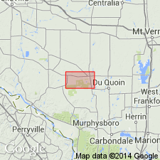
Galum limestone member of McLeansboro formation. Earthy yellow nodular limestone; fossils rare or absent. Thickness 3 feet. Top lies 6 to 19+/- feet below Cutler limestone member and base lies 85+/- feet above Herrin (No. 6) coal in vicinity of Pinckneyville and Jamestown, Perry County, southwestern Illinois. Age is Pennsylvanian.
Well exposed along Galum Creek, near Pinckneyville, Perry Co., southwestern IL.
Source: US geologic names lexicon (USGS Bull. 896, p. 795).
- Usage in publication:
-
- Galum limestone
- Modifications:
-
- Revised
- AAPG geologic province:
-
- Illinois basin
Summary:
Pg. 16 (fig. 2). Shown on correlation chart as Galum limestone in McLeansboro group. Underlies Cutler limestone; overlies Bankston Fork limestone.
Source: US geologic names lexicon (USGS Bull. 1200, p. 1459).
- Usage in publication:
-
- Galum limestone
- Modifications:
-
- Principal reference
- Revised
- AAPG geologic province:
-
- Illinois basin
Summary:
p. 11. Galum limestone. Correlation chart shows Galum limestone in Sparland cyclothem. Type locality given.
Type locality: north center sec. 13, T. 6 S., R. 4 W., Perry Co., southern IL. Well exposed along Galum Creek near Pinckneyville, Perry Co., southern IL.
Source: US geologic names lexicon (USGS Bull. 1200, p. 1459).

- Usage in publication:
-
- Galum limestone member
- Modifications:
-
- Revised
- AAPG geologic province:
-
- Illinois basin
Summary:
Pg. 34, 48 (table 1), pl. 1. Galum limestone member of Carbondale formation of Kewanee group (new). Reallocated to member status in Carbondale formation. Occurs above Allenby coal member (new) and below Danville (No. 7) coal member. Age is Pennsylvanian. Presentation of new rock-stratigraphic classification of Pennsylvanian strata in Illinois.
Source: US geologic names lexicon (USGS Bull. 1200, p. 1459).
For more information, please contact Nancy Stamm, Geologic Names Committee Secretary.
Asterisk (*) indicates published by U.S. Geological Survey authors.
"No current usage" (†) implies that a name has been abandoned or has fallen into disuse. Former usage and, if known, replacement name given in parentheses ( ).
Slash (/) indicates name conflicts with nomenclatural guidelines (CSN, 1933; ACSN, 1961, 1970; NACSN, 1983, 2005, 2021). May be explained within brackets ([ ]).