The National Geologic Map Database is migrating to a new infrastructure. We apologize for any service disruptions during this process.
|
|---|


- Usage in publication:
-
- Gallego sandstone member*
- Modifications:
-
- Original reference
- Dominant lithology:
-
- Sandstone
- AAPG geologic province:
-
- Basin-and-Range province
- Orogrande basin
Summary:
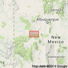
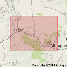
Gallego sandstone member of Miguel formation. Massive yellow sandstone containing HALYMENITIES. Thickness 93 feet. Occurs near middle of Miguel formation, about 983 feet below Bell Mountain sandstone member. Age is Late Cretaceous. Recognized in Alamosa Creek Valley [now Alamocita Creek] area, Socorro [and Catron] Cos., southwestern NM. [Alamocita Creek is in Catron County (est. Feb. 1921) and Socorro County; Magdalena quadrangle, scale 1:100,000.]
Named from Gallegos Creek, [west of Tres Hermanos Mesa, in T. 3 and 4 N., R. 7 W., Magdalena quadrangle, scale 1:100,000], Socorro Co., central NM.
Source: US geologic names lexicon (USGS Bull. 896, p. 794).
- Usage in publication:
-
- Gallego sandstone member*
- Modifications:
-
- Revised
- AAPG geologic province:
-
- Orogrande basin
Summary:
Removed from Miguel formation, a term abandoned, reassigned to Gallup sandstone as its upper member and of the Mesaverde group. Lower part of Gallup intertongues with Mancos shale. Of Late Cretaceous age. Fossils of Carlile-Niobrara age in upper part. Geologic map. Measured sections.
Source: GNU records (USGS DDS-6; Denver GNULEX).
- Usage in publication:
-
- Gallego Sandstone Member*†
- Modifications:
-
- Abandoned
Summary:
Abandoned. Term is same as Gallup Sandstone. Gallego predates Gallup, but term Gallup has been more widely used.
Source: GNU records (USGS DDS-6; Denver GNULEX).
For more information, please contact Nancy Stamm, Geologic Names Committee Secretary.
Asterisk (*) indicates published by U.S. Geological Survey authors.
"No current usage" (†) implies that a name has been abandoned or has fallen into disuse. Former usage and, if known, replacement name given in parentheses ( ).
Slash (/) indicates name conflicts with nomenclatural guidelines (CSN, 1933; ACSN, 1961, 1970; NACSN, 1983, 2005, 2021). May be explained within brackets ([ ]).