

- Usage in publication:
-
- Galesville member
- Modifications:
-
- Named
- Dominant lithology:
-
- Sandstone
- AAPG geologic province:
-
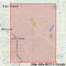
- Wisconsin arch
Summary:
It is proposed that Dresbach formation be defined to include the sandstones and shales that lie between the Red Clastic series and the Franconia in southern MN and northern IA, between the Precambrian and the Franconia in southern and central WI, and between the Keweenawan and the Franconia along the Saint Croix, and that this formation be subdivided into three members, the lower two of which are called Mount Simon and Eau Claire respectively, and that the new name Galesville member be applied to the uppermost member, which is exposed from top to bottom on the bluff of Beaver Creek at the mill dam at Galesville, WI, where it is 86 ft thick.
Source: GNU records (USGS DDS-6; Reston GNULEX).
- Usage in publication:
-
- Galesville Sandstone
- Modifications:
-
- Revised
- AAPG geologic province:
-
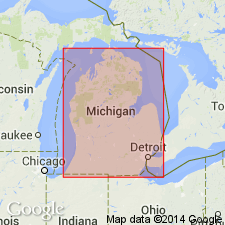
- Michigan basin
Summary:
Munising retained at Formation rank north of line shown in fig. 8. In Upper Peninsula includes Miners Castle Sandstone and Chapel Rock Sandstone Members. In Lower Peninsula Munising raised to Group rank and includes Franconia Formation, Galesville Sandstone, and Eau Claire Formations.
Source: GNU records (USGS DDS-6; Reston GNULEX).

- Usage in publication:
-
- Galesville Sandstone
- Modifications:
-
- Areal extent
- Revised
- AAPG geologic province:
-
- Michigan basin
Summary:
Munising extended to IN as Group within Potsdam Supergroup. In northwest IN, consists of the Franconia Formation (top), the Ironton Sandstone, the Galesville Sandstone, and the Eau Claire Formation. Unit includes only the Eau Claire in southwest IN, and only the Davis Formation (top) and the Eau Claire throughout most of the state. Underlies Potosi Dolomite and overlies Mount Simon Sandstone.
Source: GNU records (USGS DDS-6; Reston GNULEX).
- Usage in publication:
-
- Galesville Member
- Modifications:
-
- Overview
- AAPG geologic province:
-
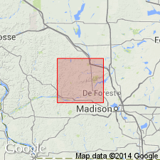
- Wisconsin arch
Summary:
Wonewoc Formation in Sauk Co. includes the lower Galesville Member, which contains quartz sand and sandstone similar to that of the Mount Simon Formation, and the upper Ironton Member, which contains bioturbated, red-stained sandstone like that of the Eau Claire Formation in the northeastern part of the county. Galesville is typically 15 to 20 m thick in northern Sauk Co. and about 50 m thick in southeastern part of county. Ironton Member is generally a few meters thick in northern Sauk Co. and less than 1 m thick in southern Sauk Co. Galesville is distinguished from the Mount Simon by its whiter color, its greater amount of quartz grains, its smaller-scale cross-bedding, and its more abundant planar bedding. Shallow marine origin suggested by Fielder (1985); fluvial and eolian origin suggested by Dott and others (1986).
Source: GNU records (USGS DDS-6; Reston GNULEX).
- Usage in publication:
-
- Galesville Sandstone
- Modifications:
-
- Overview
- AAPG geologic province:
-
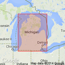
- Michigan basin
Summary:
In the southern peninsula of MI, Eau Claire, Galesville, and Franconia Formations are collectively referred to the Munising Group because of their genetic relations. In the northern peninsula, Munising is retained at formation rank. This nomenclature follows Catacosinos (1973, 1974).
Source: GNU records (USGS DDS-6; Reston GNULEX).
For more information, please contact Nancy Stamm, Geologic Names Committee Secretary.
Asterisk (*) indicates published by U.S. Geological Survey authors.
"No current usage" (†) implies that a name has been abandoned or has fallen into disuse. Former usage and, if known, replacement name given in parentheses ( ).
Slash (/) indicates name conflicts with nomenclatural guidelines (CSN, 1933; ACSN, 1961, 1970; NACSN, 1983, 2005, 2021). May be explained within brackets ([ ]).