The National Geologic Map Database is migrating to a new infrastructure. We apologize for any service disruptions during this process.
|
|---|


- Usage in publication:
-
- Gailor dolomite
- Modifications:
-
- Original reference
- Dominant lithology:
-
- Dolomite
- AAPG geologic province:
-
- Appalachian basin
Summary:
Pg. 797, 803 (fig. 3), 807-808, 811-812, 813. Gailor dolomite. Because OPHILETA, HELICOTOMA(?) UNIANGULATA, and ECTENOCERAS are exclusive Canadian index fossils, the latter two indicative of the Lower Canadian, the age of the cherty dolomite above Mosherville sandstone (new) is established as lowermost Ordovician. Name Little Falls dolomite for these beds is in error, and name Skene dolomite (Wheeler, 1942, Amer. Jour. Sci., v. 240, no. 7, p. 518-524) is not applicable because it was defined as Upper Cambrian. Hence, name Gailor dolomite is proposed for these beds. Thickness varies from about 150 feet in Saratoga region. West of Petrified Sea Gardens, formation is capped by massive 6-foot gray chert bed which locally contains CRYPTOZOON. Underlies Tribes Hill limestone in western part of area and Amsterdam limestone in eastern part of area. Section at Rock City Falls shows 12 feet of Gailor dolomite below thin Lowville limestone. Mosherville sandstone also referred to as basal member of Gailor.
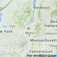
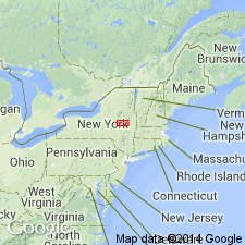
Type locality: Gailor Quarry at northern edge of city of Saratoga Springs, one-eighth mile west of U.S. Highway 9, Saratoga Co., NY.
Source: US geologic names lexicon (USGS Bull. 1200, p. 1451).
- Usage in publication:
-
- Gailor dolomite
- Modifications:
-
- Areal extent
Summary:
Pg. 85. Traced into Fort Johnson member (new) of Tribes Hill formation in Mohawk Valley. Debatable whether some of dolomite beneath the Fort Johnson in that area should be assigned to the Gailor.
Source: US geologic names lexicon (USGS Bull. 1200, p. 1451).
For more information, please contact Nancy Stamm, Geologic Names Committee Secretary.
Asterisk (*) indicates published by U.S. Geological Survey authors.
"No current usage" (†) implies that a name has been abandoned or has fallen into disuse. Former usage and, if known, replacement name given in parentheses ( ).
Slash (/) indicates name conflicts with nomenclatural guidelines (CSN, 1933; ACSN, 1961, 1970; NACSN, 1983, 2005, 2021). May be explained within brackets ([ ]).