

- Usage in publication:
-
- Fulton green shale
- Modifications:
-
- Original reference
- AAPG geologic province:
-
- Appalachian basin
Summary:
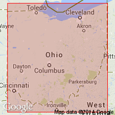
Pg. 92. Fulton green shale [Fulton shale member of Monongahela formation]. On fresh exposures is bright-green, finely laminated shale, but weathers bluish green. Thickness 0 to 5 feet. Underlies Uniontown limestone and overlies Benwood limestone. Present in West Virginia, western Pennsylvania, and eastern Ohio. Age is Pennsylvanian.
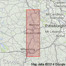
Exposed at Fulton, Ohio Co., WV.
[GNC remark (ca. 1938, US geologic names lexicon, USGS Bull. 896, p. 786): The Ohio and West Virginia Geol. Surveys in 1931 applied Arnoldsburg limestone to lower part of Uniontown limestone of previous usage, and restricted Uniontown to younger beds.]
Source: US geologic names lexicon (USGS Bull. 896, p. 786).
- Usage in publication:
-
- Fulton shale member
- Modifications:
-
- Overview
- AAPG geologic province:
-
- Appalachian basin
Summary:
Pg. 36, 37. Fulton shale member of Monongahela formation. Thin shale member which in eastern Ohio occurs about midway between the Sewickley and Uniontown coals. In Jefferson County, Ohio, and northwestern West Virginia, underlies Arnoldsburg limestone. Age is Late Pennsyvlanian.
Source: US geologic names lexicon (USGS Bull. 1200, p. 1442).
- Usage in publication:
-
- Fulton shale and sandstone member
- Modifications:
-
- Overview
- AAPG geologic province:
-
- Appalachian basin
Summary:
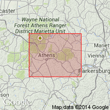
Pg. 158 (table 13), 178, 180. Fulton shale and sandstone member in Arnoldsburg cyclothem. [Considered an informal classification.] In Athens County, Ohio, olive-green shaly sandstone that occurs above Benwood coal bed has been identified as the Fulton "green" shale. Here, the Fulton shale is separated from Benwood coal by bedded sequence of silty shale or fine-grained sandstone that contains shaly partings and averages 4.5 feet in thickness. In Monongahela series. Age is Late Pennsylvanian.
Source: US geologic names lexicon (USGS Bull. 1200, p. 1442).
For more information, please contact Nancy Stamm, Geologic Names Committee Secretary.
Asterisk (*) indicates published by U.S. Geological Survey authors.
"No current usage" (†) implies that a name has been abandoned or has fallen into disuse. Former usage and, if known, replacement name given in parentheses ( ).
Slash (/) indicates name conflicts with nomenclatural guidelines (CSN, 1933; ACSN, 1961, 1970; NACSN, 1983, 2005, 2021). May be explained within brackets ([ ]).