The National Geologic Map Database is migrating to a new infrastructure. We apologize for any service disruptions during this process.
|
|---|


- Usage in publication:
-
- Frog Lake Till
- Modifications:
-
- Original reference
- AAPG geologic province:
-
- Sierra Nevada province
Summary:
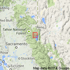
Pg. 821. Frog Lake Till. Named for glacial deposits at heads of many tributary valleys north of Lake Tahoe. At type locality moraine crests are numerous, rather sharp, and are up to about 40 feet above surrounding terrain. Stream draining Frog Lake has cut vertically about 20 feet through one moraine but not laterally. Not possible to say if Frog Lake Till represents separate advance or standstill during Tioga deglaciation. Evidence from Frog Lake suggests a readvance. If it is a readvance, it is thought to have taken place soon after disappearance of Tioga glacier, or at least its withdrawal farther into the cirque. Recognized in northern California. Age is Pleistocene.
Type locality: Frog Lake, a cirque lake about 3.5 mi north of Donner Pass, [Nevada Co.], eastern northern CA. All deposits are within five-eighths mi of cirque wall and between 7,400 and 7,900 ft in elevation.
Source: US geologic names lexicon (USGS Bull. 1350, p. 277).
For more information, please contact Nancy Stamm, Geologic Names Committee Secretary.
Asterisk (*) indicates published by U.S. Geological Survey authors.
"No current usage" (†) implies that a name has been abandoned or has fallen into disuse. Former usage and, if known, replacement name given in parentheses ( ).
Slash (/) indicates name conflicts with nomenclatural guidelines (CSN, 1933; ACSN, 1961, 1970; NACSN, 1983, 2005, 2021). May be explained within brackets ([ ]).