

- Usage in publication:
-
- Frenchville formation
- Modifications:
-
- Original reference
- Dominant lithology:
-
- Sandstone
- AAPG geologic province:
-
- New England province
Summary:
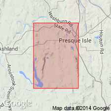
Pg. 16 (table 2), 31-33, pl. 1. Frenchville formation. Name proposed to replace Williams' and Gregory's (USGS Bull. 165, 1900) Sheridan sandstone. Name Sheridan preoccupied. Principally light-gray or buff-gray fine-grained feldspathic sandstone. Estimated thickness about 1,110 feet. Overlies Pyle Mountain argillite (new); underlies Perham formation (new). Age is Silurian.
Type area (Williams and Gregory): along Aroostook River and nearby roadcuts in vicinity of town of Sheridan in Ashland quadrangle, northeastern ME. Named from town of Frenchville 4 mi east of Sheridan, Presque Isle quadrangle, northeastern ME.
Source: US geologic names lexicon (USGS Bull. 1350, p. 275).
- Usage in publication:
-
- Frenchville Formation*
- Modifications:
-
- Overview
- Areal extent
- Dominant lithology:
-
- Sandstone
- Conglomerate
- AAPG geologic province:
-
- New England province
Summary:
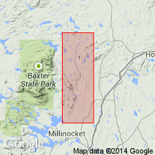
Pg. 122-123. Frenchville Formation. Gray fine- to coarse-grained feldspathic sandstone and conglomerate in narrow outcrop belt in southeast corner of Stacyville quadrangle are classed with Frenchville Formation of Presque Isle area, northeastern Maine. Most of this rock in Stacyville quadrangle is medium- to coarse-grained sandstone in massive beds 2 to 4 feet thick, but contains lesser amounts of fine-grained quartzitic sandstone and some conglomerate. Similarity of the rocks and their fossils of the Stacyville quadrangle to the Frenchville Formation of Presque Isle area governed decision to identify them as Frenchville, although no rocks are so identified in the 50-mile interval that separates these outcrop areas. From structural data the position of the Frenchville in the Stacyville quadrangle is equivocal; however, implicit in its identification as Frenchville is its stratigraphical position low in the Silurian sequence, and this presumably beneath the Allsbury Formation in the core of an anticline.
Source: US geologic names lexicon (USGS Bull. 1350, p. 275).
For more information, please contact Nancy Stamm, Geologic Names Committee Secretary.
Asterisk (*) indicates published by U.S. Geological Survey authors.
"No current usage" (†) implies that a name has been abandoned or has fallen into disuse. Former usage and, if known, replacement name given in parentheses ( ).
Slash (/) indicates name conflicts with nomenclatural guidelines (CSN, 1933; ACSN, 1961, 1970; NACSN, 1983, 2005, 2021). May be explained within brackets ([ ]).