The National Geologic Map Database is migrating to a new infrastructure. We apologize for any service disruptions during this process.
|
|---|


- Usage in publication:
-
- Freel Peak Granodiorite*
- Modifications:
-
- Original reference
- Geochronologic dating
- AAPG geologic province:
-
- Sierra Nevada province
Summary:
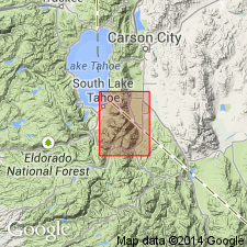
Freel Peak Granodiorite. Intrusive rocks exposed in the central part of the Freel Peak quadrangle, central Sierra Nevada, California and Nevada, are here named the Freel Peak Granodiorite. Consists of light-gray, medium-grained, biotite granodiorite containing distinctive quartz aggregates, potassium feldspar phenocrysts, and ragged biotite flakes. A pinkish-orange to gray porphyritic body exposed north of Jobs Peak is regarded as a variant of the Freel Peak Granodiorite. Intrudes the quartz diorite of Jobs Canyon; is intruded by the tonalite west of Waterhouse Peak, the Burnside Lake Adamellite, and the Bryan Meadow Granodiorite. Age is Late Cretaceous, based on potassium-argon (K-Ar) ages of 93.2 +/-3 Ma (hornblende) and 82.9 +/-1.5 Ma (biotite), citing E.H. McKee (USGS, oral commun., 1981).
Type locality: exposures at Armstrong Pass, in E/2 sec. 1, T. 11 N., R. 18 E., Freel Peak [7.5-minute quadrangle], El Dorado and Alpine Co. line, northern CA. Named from Freel Peak, 2 mi north of Armstrong Pass, in sec. 25, T. 12 N., R. 19 E., [along El Dorado/Toiyabe National Forests bdry.], El Dorado and Alpine Co. line, northern CA.
[See also Armin and others, 1984, Geol. map Markleeville quadrangle, USGS Misc. Inv. Ser. Map I-1474, scale 1:62,500.]
[Typographical error (US geologic names lexicon, USGS Bull. 1565, p. 114): principal reference of Bryan Meadow Granodiorite is John and others, 1981 (USGS Misc. Field Stud. Map MF-1322-A), not this publication.]
Source: Publication; US geologic names lexicon (USGS Bull. 1565, p. 114).
For more information, please contact Nancy Stamm, Geologic Names Committee Secretary.
Asterisk (*) indicates published by U.S. Geological Survey authors.
"No current usage" (†) implies that a name has been abandoned or has fallen into disuse. Former usage and, if known, replacement name given in parentheses ( ).
Slash (/) indicates name conflicts with nomenclatural guidelines (CSN, 1933; ACSN, 1961, 1970; NACSN, 1983, 2005, 2021). May be explained within brackets ([ ]).