The National Geologic Map Database is migrating to a new infrastructure. We apologize for any service disruptions during this process.
|
|---|


- Usage in publication:
-
- Four Hole Member
- Four Hole Swamp Member
- Modifications:
-
- Original reference
- AAPG geologic province:
-
- Atlantic Coast basin
Summary:
Four Hole Member of Wicomico Formation; Four Hole Swamp Member of Wicomico Formation. Upper Wicomico Formation divided into five members: Toney Bay, Dean Swamp, Sandridge, Wassamassaw Swamp, and Four Hole. The Four Hole Swamp Member contains fluvial, estuarine, and palustrine environmental facies. Age is early Pleistocene.
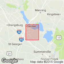
Present within the embayment of the Surry Scarp in vicinity of Four Hole Swamp, Eutawville quadrangle, eastern SC.
Source: US geologic names lexicon (USGS Bull. 1350, p. 271).
For more information, please contact Nancy Stamm, Geologic Names Committee Secretary.
Asterisk (*) indicates published by U.S. Geological Survey authors.
"No current usage" (†) implies that a name has been abandoned or has fallen into disuse. Former usage and, if known, replacement name given in parentheses ( ).
Slash (/) indicates name conflicts with nomenclatural guidelines (CSN, 1933; ACSN, 1961, 1970; NACSN, 1983, 2005, 2021). May be explained within brackets ([ ]).